Organizations responsible for environmental monitoring, especially when it comes to ‘smart development’ in environmentally sensitive areas, are increasingly using some powerful geospatial data, tools and processes to ensure minimal impact.
The sound study, assessment and monitoring of natural resources and habitats is of the utmost importance in ecosystem management. In the United Kingdom, a high priority has been placed on managing natural resources, and maintaining a balance between sustainable energy sources and a sustainable environment in which to live. It is understood that a healthy, properly functioning natural environment provides the foundation for sustainable economic growth, prospering communities and personal wellbeing.
The Department for Environment, Food & Rural Affairs (DEFRA) in the U.K. is the government department responsible for policies on environmental regulation and sustainable development. DEFRA reflects U.K. government key priorities to:
a. Support and develop British farming and encourage sustainable food production;
b. Enhance the environment and biodiversity to improve quality of life;
c. Support a strong and sustainable green economy and thriving rural communities that are resilient to climate change.
In order to ensure that these criteria are effectively met, many agencies within the U.K. are tasked with preserving the natural environment, and have become increasingly involved in the use of satellite and aerial imagery, infrared and LiDAR datasets. All of these data products are highly effective in mapping, monitoring change and supporting the assessment of natural habitats.
Environmental organizations and contractors now collect and store gigabytes and even terabytes of geographic data, which must be stored and disseminated properly to the right technical experts for analysis such as vegetation health detection, slope stability risk analysis and species change. Through these customized and highly specialized spatial models, experts are able to understand clearly the anthropogenic impact to our environment.
Some aerial surveys involve the collection of thousands of aerial images in one study. To manage these massive volumes of data, environmental monitoring organizations in the U.K. are turning to comprehensive data management, analysis and delivery solutions. These solutions must enable the organization to create a catalog of human-understandable metadata,where data can be easily searched, discovered and securely disseminated to the proper end users and technical experts.
Along with serving imagery very fast, these solutions should also provide the ability to dynamically edit data, perform analytics and extract information products on demand. Organizations can use next- generation software for performing advanced remote sensing analysis and spatial modeling to create new information. A key benefit of these kinds of solutions is that users can visualize the results in 2D, 3D, movies, and on cartographic-quality map compositions.
IMPACT OF WIND FARM DEVELOPMENT
The environmental impacts of wind farm development are always a major consideration when countries are exploring alternative energy sources. The U.K. is currently a world leader in offshore wind power generation. Wind farms tend to be ideally suited for expansive regions and coastlines where wildlife is abundant. While a good alternative source of energy, they are not without their impacts to the wildlife populations in those areas.
Understanding the environmental impacts of development is a vital step in moving forward with energy solutions. To perform proper assessment and ensure minimal impact in site selection, a number of organizations are already using geospatial solutions and imagery analysis for natural habitat evaluation and site selection. For one such project, APEM Ltd. is monitoring bird populations living in areas zoned for potential development, or in areas already developed for wind power generation. APEM specializes in freshwater and marine ecology assessment using aerial surveys.
Using a proprietary algorithm for identifying and enumerating birds from aerial photographs, they have collected tens of thousands of images. To date, APEM have amassed over 87 Terabytes of aerial photography using 4 Leica RCD30 medium-resolution cameras on five aircraft.
In order to handle this massive quantity of data, core management and delivery capabilities are required. Key solutions from Intergraph have been used to enable the customer to organize and disseminate data to the technical analysts who examine and count birds captured in every image. Other Intergraph solutions are also used for data authoring and generating terrain models of the actual bird habitat. By using these products, APEM is able to understand and process massive amounts of aerial data required for supporting the planning and development, as well as monitoring the impact of wind farms in this region.
OTHER ENVIRONMENTAL MONITORING USES
Through our U.K. partner Sterling GEO, Intergraph has been able to implement solutions in other unique ways. For example, the Scottish Environmental Protection Agency (SEPA) monitors and reports on the state of Scotland’s environment. The natural environment makes up 80 percent of Scotland’s land mass and is home to more than 1,000 different species of birds living in large wetland areas. Correspondingly, SEPA deals with massive volumes of data regarding various bird species and wildlife habitat. SEPA uses Intergraph solutions and has been able to effectively assess and monitor the country’s natural wetlands. See FIGURE 1.
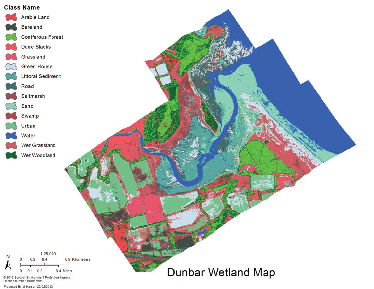
FIGURE 1.
Using ERDAS IMAGINE, SEPA is able to monitor and report upon wildlife activity in the Dunbar wetland region.
In addition, Natural England is an organization that provides environmental consulting to the U.K. government. They recently ran a pilot project looking at line- of-sight analysis along the major walks of England.
The organization’s applications team used Inter-graph solution ERDAS IMAGINE to analyze a 10km stretch of the Pennine Way, ultimately creating a virtual walker 2m high and measuring what they could see, based on a 5m Digital Elevation Model. From there, the group collated the data into a single GIS layer and visualized it in 3D. What is unique about this use case is that the whole process took less than 2 hours, including computation time. See FIGURE 2.
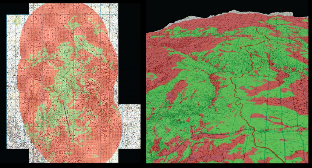
FIGURE 2.
Natural England was able to develop enhanced 3D visualization using ERDAS IMAGINE Virtual GIS.
Scotland is renowned for its areas of outstanding natural beauty and rugged landscape. The Scottish Natural Heritage is funded by the Scottish Government to promote and care for the country’s natural environment. The nation’s peatlands and bogs provide a natural water source that help maintain steady flow rates in salmon rivers, sheep grazing and recreation areas. The organization conducts in-depth vegetation analysis to properly monitor these areas, and runs ERDAS IMAGINE to utilize unique mosaicking, stacking and powerful segmentation capabilities for environment classification and assessment. See FIGURE 3.
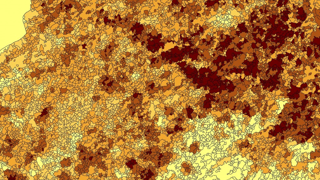
FIGURE 3.
ERDAS IMAGINE is used for the mosaicking, stacking, creating segmentation, and the NDVI indexing of a bog in Scotland.
FUTURE OF ECOSYSTEM MONITORING
Pressures of an expanding global population, increasing energy demands and the growing responsibility we must take to manage our environment drive us to create smart and sustainable policies that minimize the impacts of development on the natural world.
Sensitive environmental regions of the world have become beacons—sign-posts even—to warn us of the impact we humans can have if development is not kept in check. Now more than ever, it is our responsibility to constantly monitor the impacts of our man-made ‘improvements,’ and ensure that our activities within nature do as little harm to the environment as possible. Whether we’re overseeing the wetlands and peatlands of Scotland, or examining nesting bird populations whose mating regions are being threatened by man, detailed analyses help us to understand where we must modify our activities in these areas, and furthermore how we should advise governments and inform useful policy-making.
Accurate, detailed geospatial data is now more available and important than ever. New lifecycle management solutions combine best-in-class products with enterprise geospatial information management, enabling environmental monitoring organizations to simplify and control how data and workflows are maintained, shared, accessed and applied. This ultimately enables rich data stores to be effectively used in ways that directly impact smart development. As the world changes, the right geospatial data management solutions will provide key insights for sustaining the health of our planet in the near and long term.


