DigitalGlobe has a long history of providing imagery for disasters and crises across the globe, ranging from war crimes in Sudan to the wildfire devastation in Colorado. The insights provided by combining imagery, geospatial analytics and all-source analysts can make a significant difference in evacuation planning, disaster response, recovery, and rebuilding in regions worldwide.
As a result of DigitalGlobe’s recent combination with GeoEye, DigitalGlobe is equipped with a more advanced satellite collection system and some of the world’s best geospatial production and analysis professionals. In fact, DigitalGlobe’s constellation of five satellites can collect more than 1 billion square kilometers of imagery per year.
In order to add crowdsourcing analysis and deliver even more value to customers, DigitalGlobe acquired Tomnod, Inc., a crowdsourced intelligence pioneer. Tomnod has been at the forefront of innovation in the growing field of crowdsourcing of Earth observation imagery, combining their advanced algorithms with deep GIS and imagery knowledge. DigitalGlobe’s acquisition of Tomnod has enabled the company to provide more timely insights and information of critical events worldwide.
THE POWER OF THE PEOPLE TURNS DATA INTO ANSWERS
Tomnod’s crowdsourcing system helps DigitalGlobe achieve its vision of being the indispensable source of information about our changing planet by the year 2020. To effectively leverage the wisdom of the crowd, data reliability is key. Tomnod’s advanced data reliability algorithm, CrowdRank, ensures that contributions from the crowd are properly filtered and weighted to maximize accuracy. By tracking crowd members’ contributions over time, CrowdRank is able to rank the individual members of the crowd by tracking the areas of agreement and disagreement. This enables the system to identify inaccurate and even malicious contributions to truly leverage the wisdom of the crowd.
DigitalGlobe will continue offering Tomnod’s rapid information capture and validation services directly to customers. In addition, information gained by the service will increasingly act as a key data source for DigitalGlobe’s analytics team, enabling them to provide more accurate insight and analysis to customers faster.
DISASTER MANAGEMENT SUPPORT
Since the beginning, DigitalGlobe has excelled in meeting customers’ needs for the quick delivery of satellite imagery, whether for military, environmental or humanitarian efforts. Satellite images provide an effective way to gauge the damage from disasters through comparisons of before-during-and-after images that geospatial analysts can use to provide answers to the right people. In fact, DigitalGlobe’s FirstLook service, which monitors disasters and crises worldwide, leverages its satellite constellation and ground infrastructure to collect and deliver up-to-date imagery of an event to customers in as little as four hours.
“Tomnod’s advanced data reliability algorithm, CrowdRank, ensures that contributions from the crowd are properly filtered and weighted to maximize accuracy.”
Before Hurricane Sandy hit the East Coast last October, DigitalGlobe satellites captured images of the affected areas, enabling the employment of change detection to narrow in on the most damaged areas. See FIGURE 1. And, even before Tomnod was part of DigitalGlobe, their crowd helped DigitalGlobe deliver insights to end users during this national disaster.
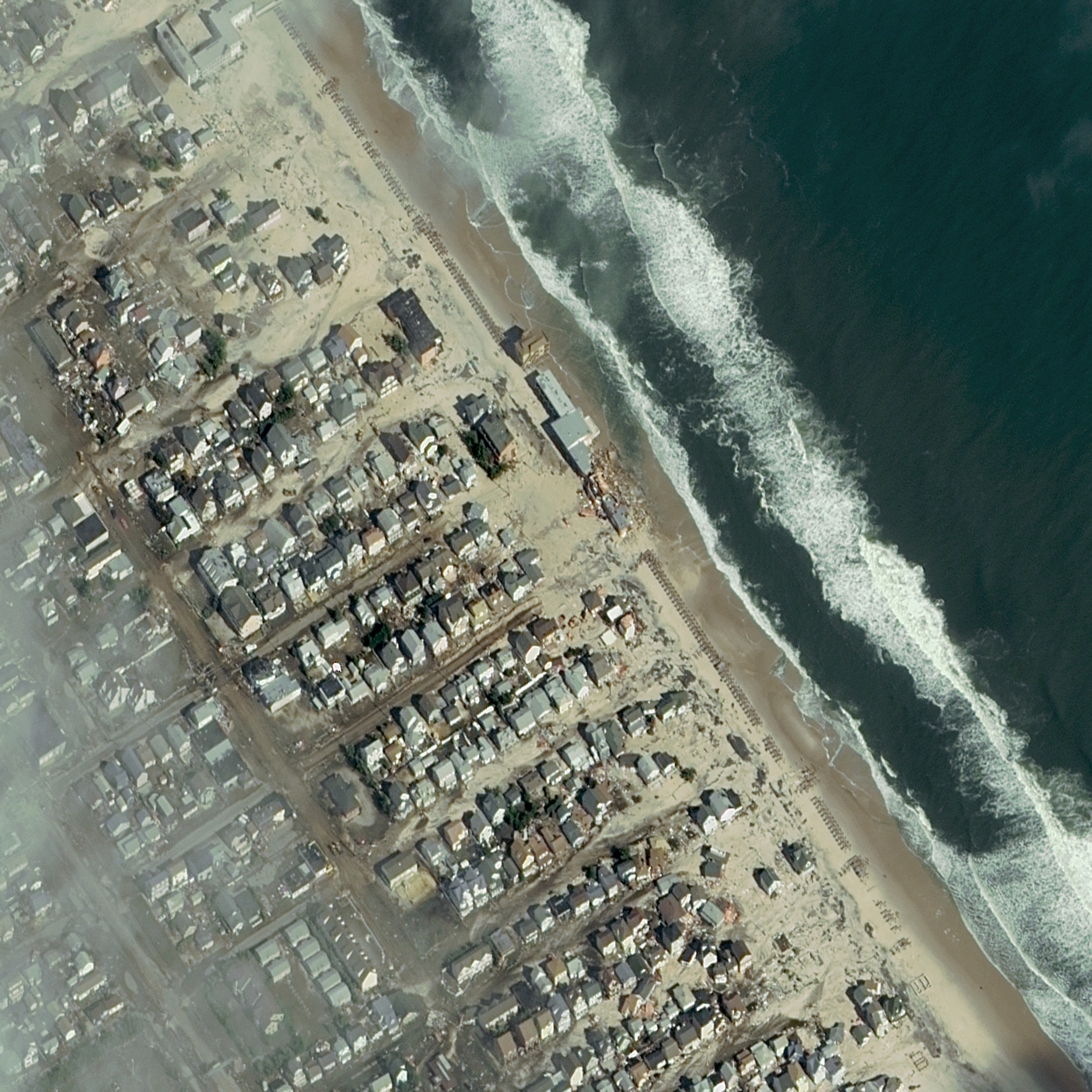
FIGURE 1.
Aftermath of Hurricane Sandy, Seaside Heights, N.J., Oct. 31, 2012. Image courtesy of DigitalGlobe.
After the storm hit, DigitalGlobe’s analysts quickly staged the before-and-after imagery within hours of collection so rescue workers and relief personnel could quickly understand the most affected areas and how to route first responders and relief supplies. As crowdsourcing comes of age, it reinforces what has always been true: the power of people makes the ultimate difference.
EXPANDED REMOTE GROUND TERMINALS FOR MORE REAL-TIME DATA
Over the last two years, DigitalGlobe also expanded the company’s ability to download imagery quicker and cover more of the Earth’s surface within a shorter window of time. The result is a much shorter period of time between data collection and product delivery by lever-aging DigitalGlobe’s worldwide network of polar and equatorial remote ground terminals (RGTs). DigitalGlobe’s RGTs collect imagery downloaded from the company’s satellites and send it to their facilities for processing.
All satellites have a limited amount of memory on board. As DigitalGlobe’s satellites fly their orbits, the faster the satellites have access to a ground terminal, the faster they can download those images and have them sent back for processing. Clearing out the memory makes room for more images. At any one time, the Earth’s land mass is within view of an antenna so images can rapidly be downloaded to an RGT and sent back to DigitalGlobe. This speed is particularly crucial during disasters.
Last summer during Colorado’s devastating wildfires, DigitalGlobe was able to take images of the burn area and access a remote ground terminal to quickly download the images. This enabled analysts to identify the damaged neighborhoods and hotspots and get hard copy images into the hands of firefighters within a few hours.
DigitalGlobe has a constellation of five high-resolution satellites, a worldwide network of polar and equatorial remote ground terminals, and billions of square kilometers of archived, high-resolution imagery. These capabilities will now be supplemented with the power of Tomond’s crowdsourced insight. By combining the speed, accuracy and capacity of DigitalGlobe’s constellation with the crowd, DigitalGlobe will be able to deliver answers and insights more quickly than ever before.
DigitalGlobe is driven by its purpose, vision and values and plans to continue growing and bringing attention to world issues through satellite imagery and analysis, helping first responders on the ground after major world events. The new DigitalGlobe analytics team includes expert analysts from all over the globe who have experience in disaster management, predictive analytics and now crowdsourcing. DigitalGlobe strives to enable the world to harness the power of human insight, satellite imaging and geolocation technology to make a difference on a large scale.

Stephen Wood
V.P. DigitalGlobe Analytics

Shay Har-Noy
Director, Research
and Development
DigitalGlobe, Inc.
Longmont, Colo.
www.digitalglobe.com