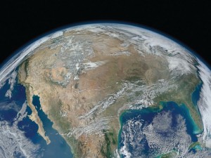
Above Featured Image: The eastern side of Russia’s Kamchatka Peninsula juts into the Pacific Ocean west of Alaska. In this winter image, a volcanic terrain is hidden under snow-covered peaks and valley glaciers feed blue ice into coastal waters. Image taken Feb. 17, 2002 by ASTER satellite. Image courtesy of U.S. Geological Survey, Earth Resources Observation and Science (EROS) Center.

Myrna James Yoo
Publisher: Apogeo Spatial (formerly Imaging Notes)
and LBx Journal
Owner: Blueline Publishing LLC
DEAR READERS,
Welcome to the realization of a dream: the relaunch of Imaging Notes magazine as Apogeo! We are working to provide you with a more compelling, visually stimulating read and to illuminate the world’s most pressing problems through imagery and inspiring solutions.
Over a decade ago, I took an 18-month backpacking trip around the world, solo. As a Kansas farm girl, I found my worldview expanded in a way that I craved. It had an effect on me similar to that of seeing the Earth from space: It was truly permanently transformative. And I did not see boundaries.
Political boundaries exist, but can’t be seen from space, or from a café in a mountain village, from the foot of a glacier, from a tree house near the ocean, from a local market, or from a World Cup game. What can be seen from traveling, and from space, is that we are all on this planet together.
Our ecosystem doesn’t ‘see’ political boundaries either; it expands beyond them. Rivers flow through them, affecting everyone along the banks, regardless of nationality. Everything in our environment is interconnected—linked and co-dependent. Apogeo is founded upon this connectedness and mutual dependence.
What we can see from space are the manmade boundaries. We can see where we have carved up the land into cities and airports and highways and crop circles. We can see where we have scarred the land. We must maintain this macro view and take responsibility for what we are doing to our planet.
While traveling, I saw evidence of the need for change. One of the most profound experiences was witnessing the melting of Fox Glacier in New Zealand. As we drove closer to it, signs appeared, saying, “In 1975, the glacier was here,” and then farther along, “In 1990, the glacier was here.” Here is an excerpt from my journal, Feb. 28, 1999:
“Fox Glacier is melting! Wow! Chunks of ice as tall as buildings are falling into the cold roaring river of melting ice. It sounds like a gunshot, or cannon. The ice is so beautiful, curved like a cave at the main melting point, streaked in dark and light blues and whites…Global Warming…”
I knew I needed to learn more. The documentary Chasing Ice about National Geographic photographer James Balog’s project “The Extreme Ice Survey” shows glacier melt using remotely controlled stationary cameras attached to rocks near glaciers around the world. It won the American Documentary Cinematography Prize at the 2012 Sundance Film Festival. Apogeo is using this power of imagery to tell stories, as well.
For our species to survive, we must keep this macro view—the satellite’s perspective of our planet. Apogeo is communicating the power of geospatial tools and technologies in managing the world’s environment and scarce resources, so that the global population has the security of water, food, and energy. With fresh, relevant insights from expert contributors, stunning visuals and clear examples of the technologies, those who make critical policy and business decisions about the world’s resources will understand and be inspired by the visual and actionable power of remotely sensed data.
My professional journey has brought me here, and I could not be more grateful to be in a position to share this important information. While I am not a geospatial expert, I have become very passionate about this since my company acquired Imaging Notes nine years ago. As a career publisher, I know what makes a great publication, and have worked to apply that knowledge here.
Join us as advocates for Earth observations!
- Subscribe: www.locationalliance.net/subscribe
- Send your article ideas via email.
- Advertise with us. We reach your audience of people who use geospatial data and tools every day. It is a good investment, and we appreciate the support.
We cannot do this without you. Thank you!
Warmly,
Myrna James Yoo, Publisher


