SHELLY-ANN JULES-PLAG / PRESIDENT / TIWAH UG / WWW.TIWAH.COM / GERMANY
AND HANS-PETER PLAG / DIRECTOR / MITIGATION AND ADAPTION RESEARCH INSTITUTE
OLD DOMINION UNIVERSITY / WWW.MARI-ODU.ORG / NORFOLK, VA
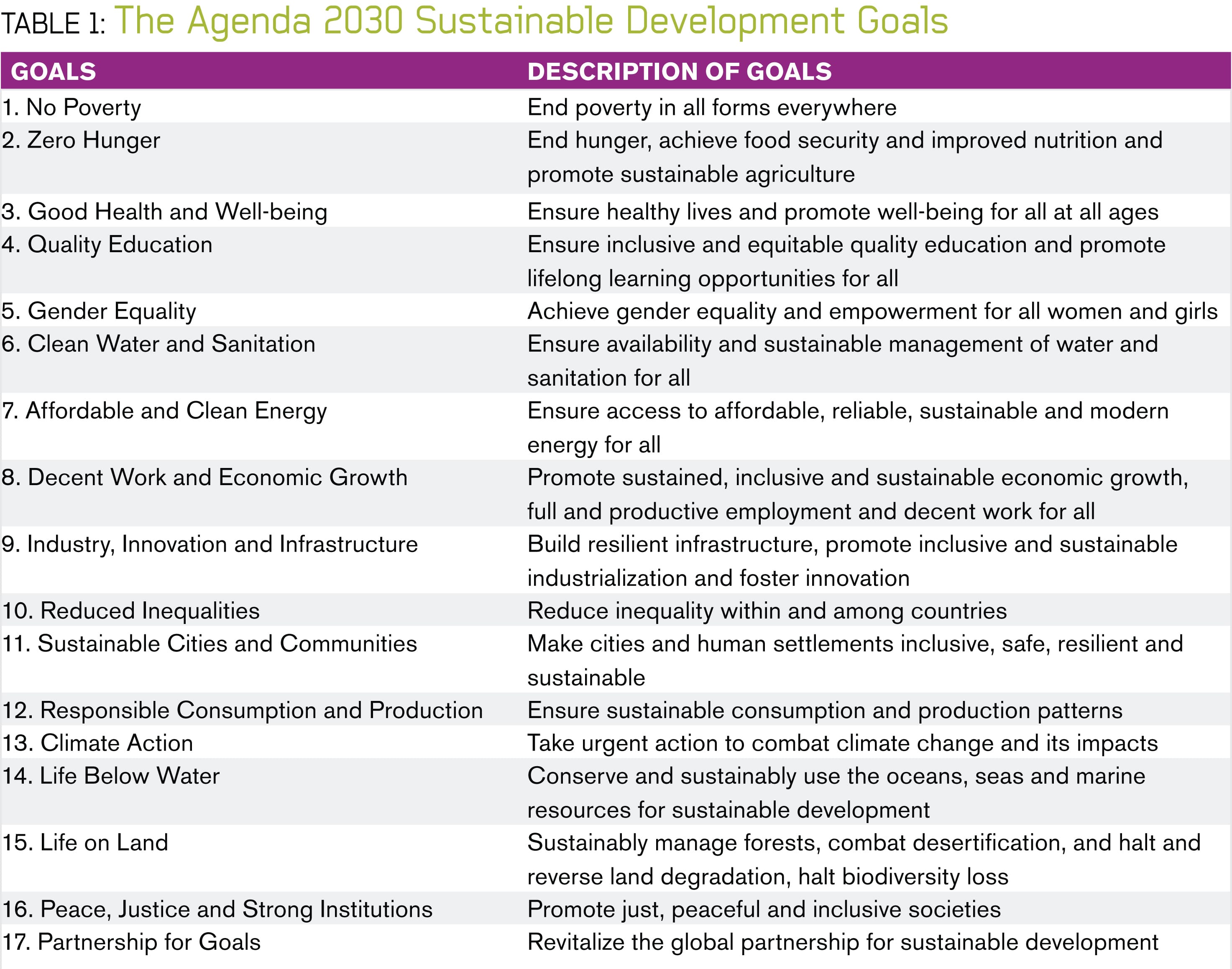
In October 2015, the United Nations’ Plenary agreed on Agenda 2030, the “Road to Dignity,” as the Secretary General of the United Nations denotes it, which aims to achieve seventeen ambitious Sustainable Development Goals (SDGs) by 2030. The SDGs cover almost all areas of human activities and their impact on Earth’s life-support system (Table 1).
THE COMPLEX SYSTEM CHALLENGE
Each of the broad goals has a set of associated tangible targets. Each target comes with a set of target-specific indicators to measure the progress towards the targets. Making progress towards these targets will require the development of policies and the implementation of specific actions that can facilitate this progress.
It is a foregone conclusion that due to the broad nature of the goals and the global intergovernmental involvement achieving each individual goal presents a complex system challenge. All goals pose highly complex problems to society. For many of the goals it is not evident that they are achievable or achievable by 2030. For example, SDG 1 aims at “Ending poverty in all its forms everywhere.” However, the absolute number of people living in extreme poverty has not changed very much since 1800, when an estimated 95% of the global population of close to 1 Billion was living in extreme poverty, although the fraction has gone down very much due to a rapid growth in population since then. Some goals may not be understood in the same way in different countries and cultural settings. For example, SDG 5 has the aim to “Achieve gender equality and empower all women and girls,” and it is not clear that this goal is understood across all cultural and religious settings in the same way.
An important question to ask is whether the targets as they are defined will actually bring us closer to the goals. This question can only be answered by fully acknowledging the complex challenge each of the goals presents to society. There are research needs to better understand the systemic conditions that are required in order to make progress toward the targets1 and to assess to what extent reaching the targets also implies reaching the goals.
Another challenge is the interconnected nature of the goals and targets, which requires straddling the interests of different policymaking departments at national levels. For example, how can conflicting requirements for achieving “No Poverty” (Goal 1) and “Zero Hunger” (Goal 2) on the one side and “Life Below Water” (Goal 14) and “Life on Land” (Goal 15) on the other side be resolved? Additionally, the interconnected nature of the goals and targets poses a cross-country challenge considering the different interests and priorities of policymakers in different countries due to inherent differences in cultures and the perception of risk. The priority given to sustainability over other goals also differs from country to country and policymaker to policymaker.
Together, this mesh of issues presents a challenge to achieving the overarching objective of putting the world on a sustainable course. It is clear, however, that making progress towards the SDGs requires Earth observation and science support to address the questions that need to be raised for each goal:
1. To what extent are the goals achievable?
2. Are the goals well-defined and understood in different countries in comparable ways?
3. How can the complexity of the goals and associated targets be accounted for in policymaking?
4. Are the targets sufficiently focused on achieving the goals?
5. What policies and actions can facilitate progress towards the targets?
6. Are the indicators well-defined and providing a measure of progress towards the targets and goals?
Open data, as strongly promoted by the Group on Earth Observations (GEO), is mandatory for the monitoring of progress towards the SDG targets,2 and a refocusing of Earth observations and science support on the needs of the Agenda 2030 is central for making progress in the global effort for sustainable development.3 The GEO Initiative 18 “Earth Observations in Service of the 2030 Agenda for Sustainable Development” facilitates Earth observation-based support for the Agenda 2030. However, answering the questions requires more science-based tools. Here, we look at the capability of two approaches to addressing some of these questions. We look at the benefits and limitations of an Agent-Based Model (ABM) approach and a GeoDesign approach.
AGENT-BASED MODELS APPLIED
TO GENDER INEQUALITY
Equation-based models have very limited value for problems as complex (and wicked) as reaching the targets and SDGs4. The advantage of ABMs is in the ability to provide an environment for us to experiment and explore when we are not totally clear on all of the issues impacting a problem. Predictions can come later when we are better informed and the explicit nature of the ABM has provided tested evidence of certain results. During the programming phase of ABM development, we need to formulate a clearly defined problem because computers are not equipped to handle the ambiguity of an ill-defined concept.
This is where the power of the ABM manifestation is twofold. Firstly, due to the need for formalized rules, we can look at and have a better understanding of the impact of the assumptions that are made in our interpretation of the complex system (i.e., system composition such as boundaries, time-frame, scale, etc.). It allows us to look at various scenarios, test assumptions, assess internal model consistencies, and address sensitivities such as relation to data. Experimentation with the ABM helps us to identify the most relevant aspects and the core issues impacting our goals.
ABMs provide avenues for the incorporation of domain expertise in a rigorous manner. With this, the ABM development also guides data collection and illuminates the core dynamics4. The iterative process of ABM development facilitates a more defined and eventually more refined model, ultimately giving us better direction with respect to where efforts should be placed to arrive at the desired goal.
The second benefit of the formalization of rules is that the model can be generalized and applied over different domains, providing the value of repeatability.
To illustrate the versatility of ABMs, we look at Goal 5 (Gender Equality, see Table 1). The forms of gender inequality differ across cultural regions, and the spectrum of economic and social barriers for progress towards the goal has considerable spatial variability. It would be impossible to take a comprehensive look at the scope of this goal, so here one branch of policy support is considered.
On a global scale, economic gender inequality is evident in the fact that 70% of all work is carried out by women but they only earn 10% of the global income. A specific example is subsistence farming: In societies with a large fraction of subsistence farming, the majority of the subsistence farming work is carried out by women. One of the major hurdles to gender equality in these societies is a woman’s inability to own land and gain access to financing. Most of the land is owned by men or by tribal organizations dominated by men. Most financing goes to men, thus solidifying and continuing the cycle of gender inequality. This aspect of gender inequality is broadly addressed by Target 5.a.:
5.a: Undertake reforms to give women equal rights to economic resources, as well as access to ownership and control over land and other forms of property, financial services, inheritance and natural resources, in accordance with national laws.
This target is open to interpretation and reinterpretation by all countries and policymakers. The indicators for Target 5.a are more specific, adhering to a metric. They however are decoupled from other relevant factors:
5.a.1: (a) Percentage of people with ownership or secure rights over agricultural land (out of total agricultural population), by sex; and (b) share of women among owners or rights-bearers of agricultural land, by type of tenure.
5.a.2: Percentage of countries where the legal framework (including customary law) guarantees women’s equal rights to land ownership and/or control.
In order to explore the variables associated with these indicators, the factors that directly and indirectly impact a woman’s ability to conduct subsistence farming have to be considered. The complexity involved in determining these impacts is presented in Figure 1. Based on the issues and the broad nature of the goals and targets, it is necessary to combine the goal-based “top down” approach with a practical “bottom up” approach. The “top down” approach facilitates a transportable decision support for all the SDGs, while the “bottom up” approach considers the individual factors and their specific impact on the indicator for a specific target and goal.
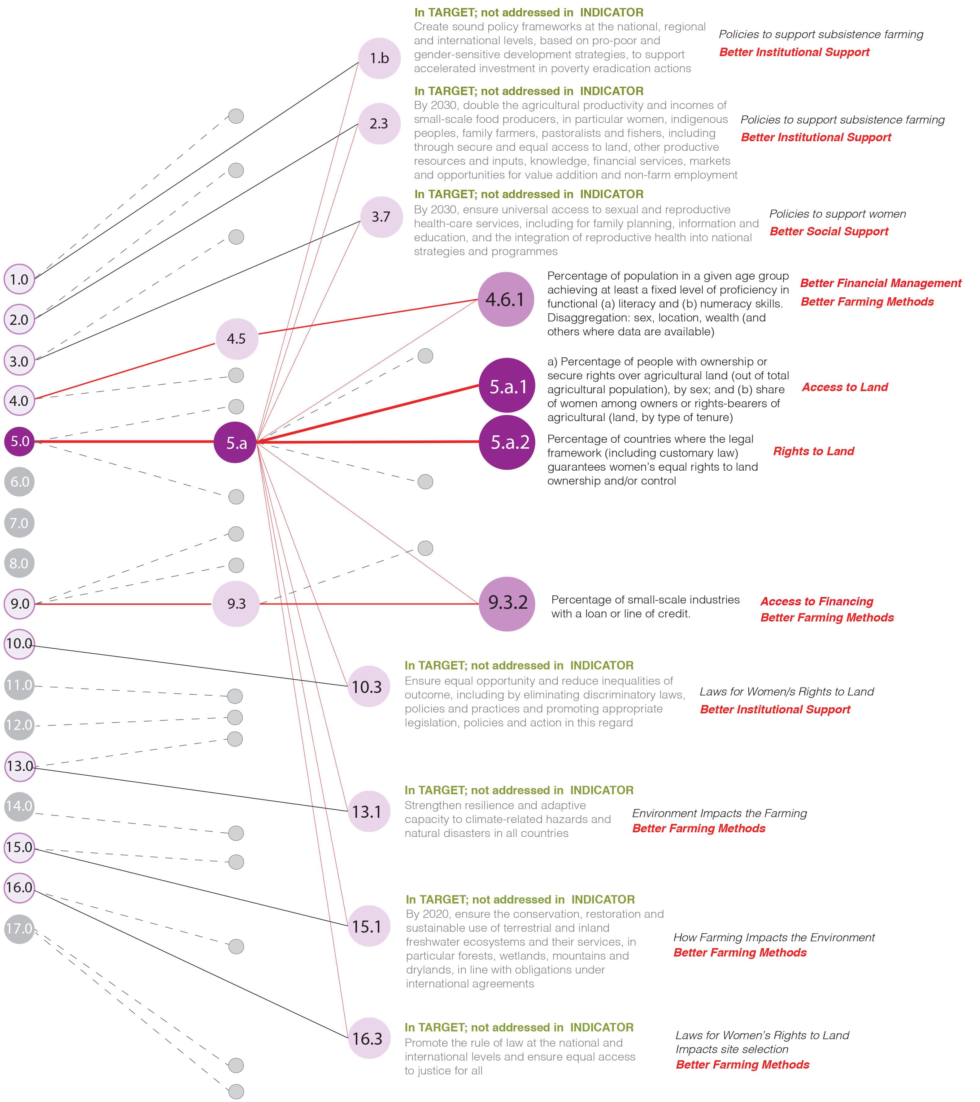
FIGURE 1: Relevance of Different Goals & Targets to Meeting Goal 5 for Gender Equality, in Subsistence Farming
As an initial step, we have developed an ABM for subsistence farming. The aim of the ABM experiment is to determine the factors that impact gender equality through land ownership and access to financing in support of subsistence farming by addressing the questions:
How does distribution of land title impact the success of female farmers? How does access to financing impact the success of female farmers? How does discrimination at market impact the success of female farmers?How does climate change impact the success of female farmers? Based on the results, what are the apparent gaps that exist between the SDG indicators and the factors the analysis identify as impactful? Based on the results, what are the policies that can be put into place to help support the success of female farmers?
Policy options in the ABM to increase equality are those that impact land ownership and access to
financing. The initial exploratory system model simulates the seasonal cycle of buying seeds (including getting financing, if needed), seeding, growing, harvesting, and utilizing (marginal) gains. The agents are the male and female farmers, land-owner societies, markets to buy seeds and fertilizers and sell produce, traditional financial sources (banks) and micro-financing actors. This model was run over the seasonal cycle for a period of 100 years for many different scenarios.
The information obtained from the analysis provides valuable guidance to the policy conditions that have the potential to improve the success of subsistence farming by female farmers and reduce gender
inequality. Decoupling land ownership from financing and introducing quota systems are two potential policy options that may be considered based on the results. Additionally, the results help to identify where there are gaps in the current formulation of targets and indicators towards more goal-focused policy development.
These considerations informed by the ABM experiment provide guidance for further developing the ABM. Of course, access to land and finance are only the start of the subsistence farming process. In order for a woman to maintain land rights she must be successful in the subsistence farming project. As outlined in this simplified view of the interrelationship of the SDGs, better farming methods, institutional
support for land ownership and financial support have contributions made through SGDs 1, 2, 3, 4, 9, 10, 13, 15 and to a lesser degree 16. Of course, additional connections with the other goals can be determined with further analysis. Here we focus on the indicators 5.a.1 and 5.a.2 and the relevance of 4.6.1 and 9.3.2. It should be noted that the ABM in its current form does not reflect the full complexity of Target 5.a, but it provides an exploratory and explanatory approach to modeling aspect of Goal 5.
GEODESIGN APPLIED
TO SUSTAINABLE CITIES
GeoDesign operates in the realm of infrastructure and the built environment. It facilitates informed development in advance of perceived needs, thus leading to sustainable construction development. The interoperability of technology facilitates integration of the subsystems of research and construction from the macro to the micro level, essentially developing conflict resolution mechanisms. It has the potential to bridge the gaps among science, social needs, economics, and policy, helping to resolve issues involved in designing the built environment. Integrating technologies offers a dynamic way of representing unseen patterns and contextual relationships across global, regional and local areas.
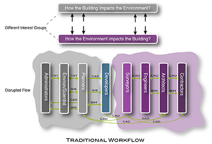
FIGURE 2.
The traditional workflow in designing the built environment
Figure 2 illustrates the traditional workflow process with disciplines contained in silos. Movement from the administrative stage to the building stage is disjointed and involves a hand-off. This often inhibits the flow of information essential for responsive design. Figure 2 also illustrates the conflicting interests that are inherent in traditional planning of human settlement. Each of the major players serves a different core interest and they speak a different discipline-specific language.
The development of a GeoDesign Hub (Figure 3) made possible by interoperability facilitates the smooth flow of captured data to the disciplines and areas where it is needed in a timely manner. Information created through “data informed processes” re-enters the Hub making the system more intelligent. Feedback from the various disciplines and crowdsourcing further informs the development of educational needs. Thus the interoperability of technology brings sustainability and its facets, such as disaster risk, resilience, adaptive capacity, and livelihood into the design argument.
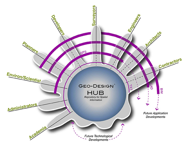
FIGURE 3. A GeoDesign Hub provides an interdisciplinary collaborative platform for the development of options
When interoperability is optimized, development has the ability to go from the point of impetus to examples of potential ‘built’ models. Similar to the ABM outlined above, it gives us the ability to explore scenario iterations in the design process. It allows the signal that triggered the course of development to be amplified throughout the course of development.
Considering Goal 11, which aims to “Make cities and human settlements inclusive, safe, resilient, and sustainable,” the GeoDesign approach can help by facilitating a better understanding of why we build and what the goals are. Even more so, it allows us to account for the relation of cities and human settlements to all the other goals.
The targets of Goal 11 focus on access to housing, transportation and green spaces, the promotion of planning and the enhancement of architecture and technology to reduce pollution and improve resilience to climate change, thus minimizing the loss of human life and resources (paying special attention to the protection of natural heritage centers). Similar to the case of Goal 5, many of the other goals have targets that are relevant to the targets of Goal 11 (Figure 4), but the indicators for these targets mostly are not focused on the scope of Goal 11. A particular challenge for the targets of Goal 11 is in the development of indicators for such wide targets. We consider two of the targets relevant to the development of sustainable human settlements:
Target 11.1: By 2030, ensure access for all to adequate, safe and affordable housing and basic services and upgrade slums.
Target 11.5: By 2030, significantly reduce the number of deaths and the number of people affected and substantially decrease the direct economic losses relative to global gross domestic product caused by disasters, including water-related disasters, with a focus on protecting the poor and people in vulnerable situations.
The associated indicators shown in Figure 4 appear to be well connected to these targets and providing a measure for progress towards the targets, but the granularity with respect to the goal is low.

FIGURE 4: Relevance of Different Goals & Targets to Meeting Goal 11 for Sustainable Human Settlements
OUTLOOK
For each of the goals, the questions formulated in the first section need to be answered thoroughly, and this requires a complex system approach. The ABM experiment introduced here underlines the versatility of ABMs for interdisciplinary and collaborative studies informing the development of policy that facilitates progress towards the targets. The GeoDesign Hub is an excellent candidate for a collaborative platform for those goals related to the built environment and its impact on society and environment. It will be important to link both the ABMs and GeoDesign Hubs to a comprehensive and open database integrating environmental with socioeconomic data and statistics. The efforts currently underway in GEO towards open and integrated data and knowledge and the linkage to models are an important development in this direction. However, it is clear that the diversity and breadth of the goals require a hybrid approach, as no one method can be a “catch-all.” The examples considered here demonstrate the importance of the interaction between goals and targets and the need to capture the factors that play a role across sets of targets and goals.
