
EXCLUSIVE INTERVIEW
Scott Soenen
The purchase of the five-satellite RapidEye constellation by BlackBridge has linked Earth observation capacity to a cloud-based system. Sensors & Systems (S&S) editor Matt Ball recently spoke with Scott Soenen, CTO of BlackBridge, about the integration process, and the company’s inroads in delivering cloud-based services that focus on the insights gleaned from commercial satellite imagery. The conversation ranged from the company’s investments to normalize their imagery for multi-temporal change detection applications, to the hosted services approach that enables ongoing monitoring of broad areas, as well as to the growing demand for such services.
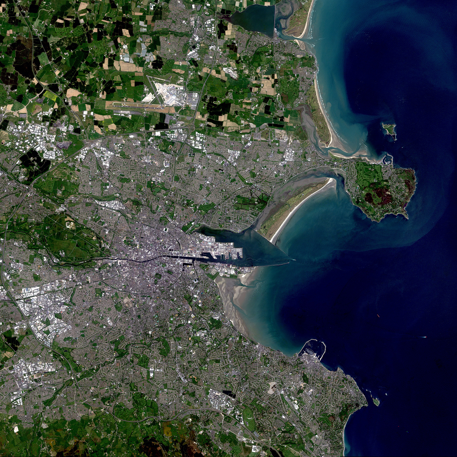
FIGURE 1.
Dublin, Ireland, collected May 27, 2012
S&S Is the fairly recent rebranding of RapidEye as BlackBridge an indication that the integration of RapidEye imaging with your other services is complete?
SOENEN Yes, we’re at the point of steady state where the transition period is behind us. We’re now growing the team, and introducing new product lines and solutions.
S&S Could you walk through a bit of the transition, how the purchase of RapidEye came about, and how it was a good fit for your existing operations?
SOENEN One of our big focuses of the transition was on integrating our operating groups in both Canada and Berlin, and also on integrating between the cloud services side of the business and the Earth observation side of the business. Our focus was to go to market as one team. Bringing these two groups together allows for some interesting combined solutions, with a focus on the geospatial industry, but also for bringing in some new concepts about what you can do with cloud services and imagery.
The whole idea of the integration of RapidEye was to introduce new products, some of which have rolled out this year. We also have a number of new imagery and cloud service product lines that we’ll be bringing to market over the next couple of years. Aside from the integration, company name and new product pipeline, not much has changed for our network of partners and customers. We continue to have the same relationships with customers, and we are really starting to focus on expanding the products that we can offer them.
S&S RapidEye came with a set number of customers. Were many of these German government customers, given the government’s investment in RapidEye? What is the mix?
SOENEN We really have a wide range of customers, particularly for the RapidEye set of products. The key industries or markets for RapidEye data are natural resources monitoring for forestry, agriculture, broad-area mapping and change detection. We certainly have German government customers, but we have government customers throughout the world. We have an international network of technology and sales partners, and I couldn’t point to one type of customer that makes up the majority of our customers. We are pretty well diversified at this point.
S&S Can you describe a bit more about the networking and cloud services business? Was much of that already focused on the geospatial market- place, as I know you have been a custom solutions provider in the geospatial market?
SOENEN Our networking and cloud services business is really less known in the geospatial industry. Certainly we’ve built up quite a knowledge base on that front through developing some of our own systems for our internal needs.
We have an extensive archive of satellite imagery, and we’ve learned quite a bit about how to architect cloud services for geospatial data. What we’ve done now is take the expertise that we’ve built in cloud services and bring that together with our expertise on geospatial data.
Previously RapidEye had a heavy focus on the value-added products and services business. We’ve really taken a step back now, and focused on bringing the industry-leading collection capacity of the RapidEye constellation to market and on using the cloud services to make that imagery easier to discover, share and use. What has made us successful is excellence in our customer service and working with our global network of partners.
S&S What are some of these services that you’ve released?
SOENEN The services recently released, and those that are coming, are focused on supporting broad-area mapping for analyzing vegetation over large areas and change monitoring. We’ve made some significant investments in enhancing the geometric accuracy of our ortho-imagery products to really enable pixel-to-pixel alignment for multi-temporal analysis for change detection. Now we feel we have the best dataset for countrywide, continental and even global monitoring. There really is no other system that has that capacity, so we’re working to build these new services on top of that capacity.
Our monitoring programs for agriculture are a good example of this. These are subscription programs that provide monthly refreshed imagery for crop analysis through the growing season. We’ve combined our cloud services to give our customers every single image that we collect over the agricultural area, and the tools to search through that imagery base to either download on their servers for their own processing, or to leverage our cloud infrastructure for value-added processing. They can stream the imagery through our infrastructure, where we can also host their applications and processes to make that move from downloading a bunch of imagery to a desktop to pushing their applications and processes into the cloud next to the imagery archive.
We think that will be increasingly important as we see this move toward analytics services that requires a heavy volume of imagery and bandwidth. It’s the only philosophy that will work as we move into the era of data mining or larger area monitoring applications—taking the work- flows and moving them to the data in the cloud.
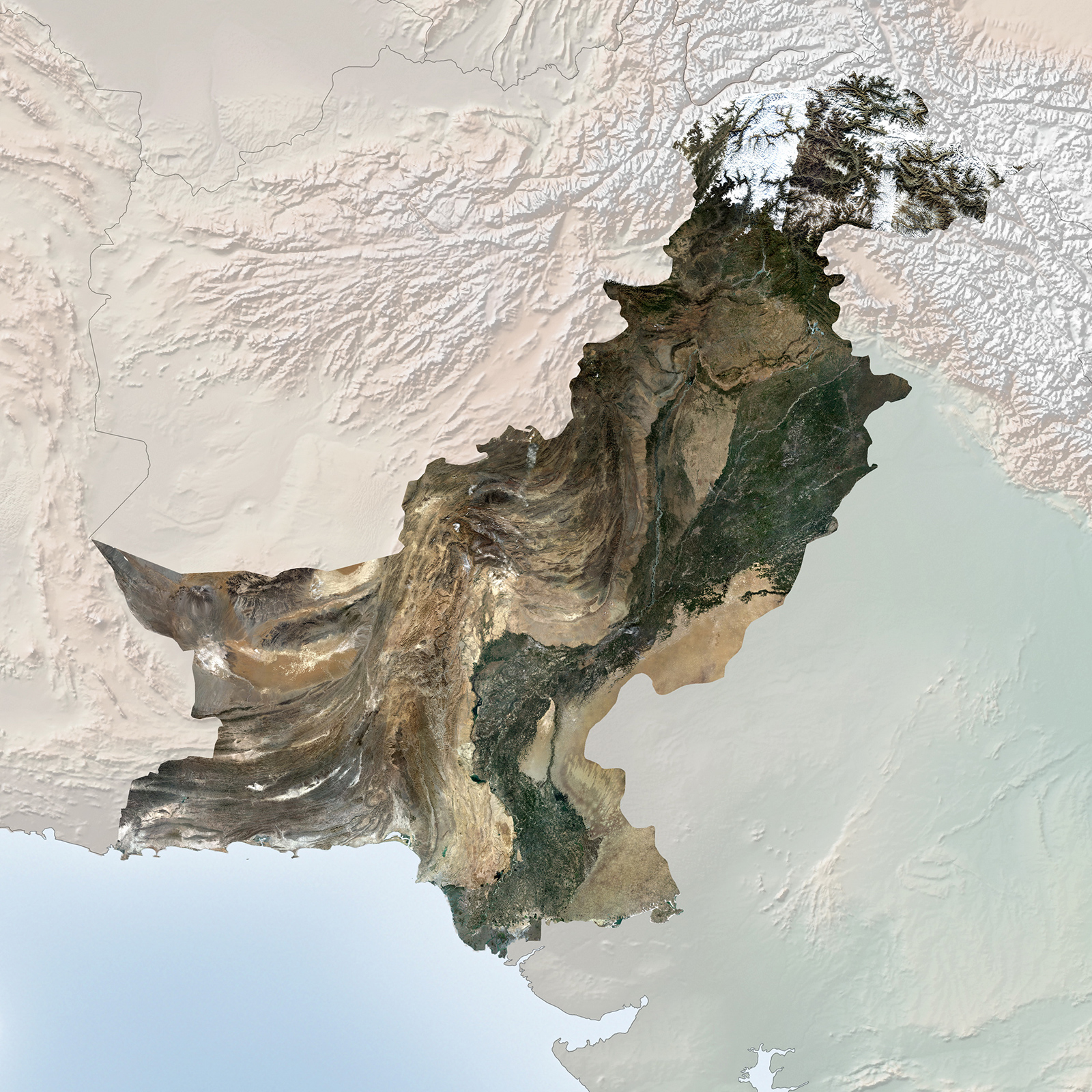
FIGURE 2.
RapidEye Mosaic of Pakistan
with cloud coverage of <1%. Timeframe of Collection: November 2010- December 2012
S&S That sounds exciting! So you’re talking about a full hosted service that could even be a branded dashboard for customers that runs all the image processing and analysis in the cloud?
SOENEN That’s absolutely what we’re doing. We’re starting to create a suite of tools based on Open Geospatial Consortium standards that users can leverage for streaming and processing. We’re also providing the general cloud infrastructure for hosting their applications.
Another thing that our cloud system makes possible is dynamic imagery services that can be updated on-the-fly, and refreshed regularly so that the user can easily consume these images. We do all the data management within our cloud infrastructure. Another really interesting thing that I’d like to highlight is our Living Image services that we have available through Esri’s ArcGIS Marketplace.
S&S Talk a little bit more about multi-temporal analysis, and the steps that you’ve done for pixel-to-pixel alignment. Are these steps auto- mated to serve the imagery more quickly, and is the change analysis also automated?
SOENEN That’s been our focus, to continue to maintain our throughput, which is up to 5 million square kilometers of collection capacity daily, and also improve our image alignment for all of the images within our archive. We’re working with a number of partners to bring new change detec- tion services to the market. You’ll see those come out over the next year. The geometric accuracy is the foundation, so that was the first step.
S&S The free Landsat imagery is another broad- area mapping sensor. Do you tie into that free imagery for any of your products or services?
SOENEN I’m glad that you brought that up. For our agricultural service, we’re also pulling together imagery from the Landsat archive, and making that available to our users through the same toolset that they use to access the RapidEye data. We see a lot of demand for this multi- source imagery, and we want to make it easy for our users to access not just RapidEye data, but any other data that is relevant to their project.
“It’s ’s really interesting to see these new players like Skybox and Planet Labs. We’re very excited about seeing these new potential partners, or seeing in what ways users can leverage the different data sources. They could use our imagery for identifying areas of change, and then using these new low-cost, high- resolution platforms to focus in, they could collect video or still images of these areas where we’ve identified change.”
S&S It’s a fascinating evolution. Access to the data, and even finding data when you know you already own it, has been an ongoing problem that seems to have been holding geospatial solutions back for some time, and now the flood gates are open.
SOENEN That’s really the impetus for a lot of our development work, creating tools for our partners and customers that make it easier for them to search our archive and discover data, but also to find our data and process it in the cloud as well. With our cloud services, we provide a means for the customer to leverage our knowledge and our purchasing power on the cloud services side, removing the data management and capital expense of servers so that they have a monthly bill that they can easily plan for, from a budgeting perspective, and also making it very easy to use.
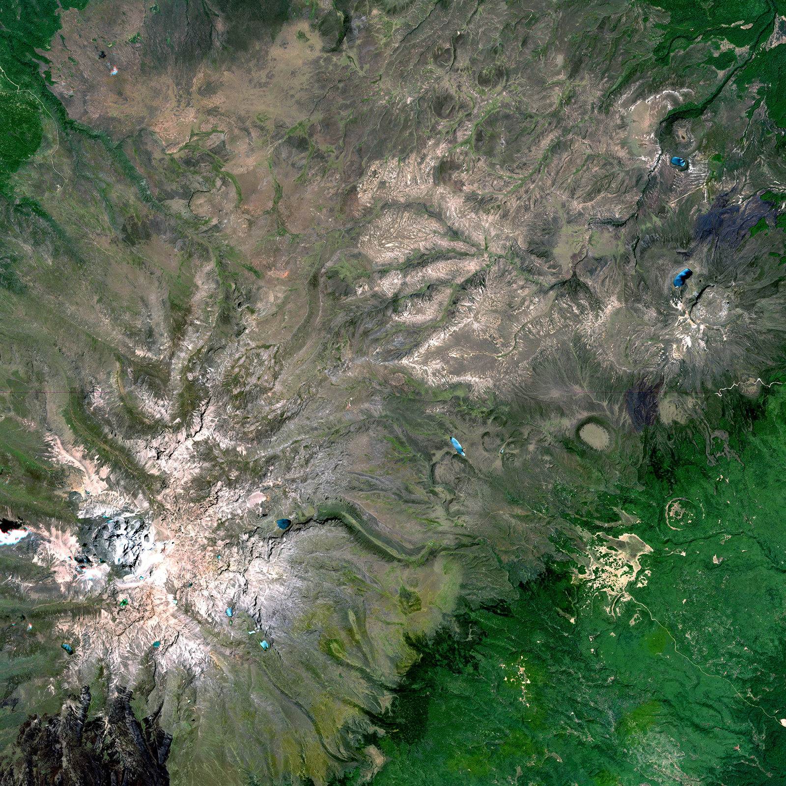
FIGURE 3.
Mt. Kenya, collected February 2, 2012
S&S There is a set timeline for any satellite in space. Are there continuation and contingency plans should one or more satellites in the constellation fail?
SOENEN We’re already deep in the process of planning our next generation of satellites. There isn’t much that I can talk about publicly at this point, but we’re well down that path and will be providing details to our partners this year.
S&S There are a growing number of small satellite makers, and a growing number of commercial satellite imaging companies. Does the growth in the market help in getting a better price? What are your feelings about the evolving com- petitive landscape?
SOENEN I think it’s a bit too early to tell. The number of options for bringing Earth observation missions to market are growing, and certainly the maturity of some of these technologies, methods and processes are really getting very interesting at this point. You could say that the original RapidEye constellation was one of the first commercial providers to take this small-sat approach. The platform is small, and it was done with a low-cost small satellite philosophy, and was innovative in launching one of our qualification models as a protoflight payload. A lot of these techniques are what some of the other small-sat providers are doing these days to reduce costs and bring their missions into orbit.
S&S Could you speak a little about the current capacity of your current satellite constellation? Certainly, it’s well documented in terms of your global coverage, and the imagery that you can collect, but maybe speak to the uniqueness of your collection capacity.
SOENEN We have a system that is very unique in the market in terms of its capacity, both on the broad swath of the satellites, and our ability to do daily revisits. Both with the collection capacity and the imaging system, we have one of the best systems for broad-area mapping and change monitoring. There really isn’t anything in the market that you can compare it to right now. This becomes really important when it comes to looking at some of these applications like change monitoring at a global scale.
It’s really interesting to see these new players like Skybox and Planet Labs. We’re very excited about seeing these new potential partners, or seeing in what ways users can leverage the different data sources. They could use our imagery for identifying areas of change, and then using these new low-cost, high-resolution platforms to focus in, they could collect video or still images of these areas where we’ve identi- fied change. The potential to use some of these multi-source imagery sets is huge, and I think it will introduce some exciting new applications in the industry as well.
S&S I get really excited about the capacity for discovery. There are so many mind-blowing discoveries that come from Earth observation, more with every new satellite-based sensor, and certainly more on the way given our
capacity to monitor our planet.
SOENEN We’re going to continue to focus on the capacity for broad-area mapping, as we see a real niche in the market for that. We’re really interested to see how users will combine our capabilities with other players.
S&S With your ties to broad-area mapping and detecting change, is the demand for monitoring keeping up with global concerns about limited resources and our need to better manage our planet?
SOENEN We’re very well positioned in that. Our system is ideally suited for some of these global change applications. One of the ones that we like to highlight is the UN REDD+ Program (Reducing Emissions from Deforestation and forest Degradation). That forest change detection application within the monitoring, recording and validation (MRV) initiative through the REDD program is one spot where RapidEye imagery really shines.
It is one of the only systems that you can use to look at an entire country and see where there is change occurring through deforestation and degradation. The other advantage about our system is the spatial resolution, as it allows for monitoring the degradation component, which is almost impossible to assess with coarser resolution systems. We’re starting to see a lot of governments looking at these types of initiatives and becoming more responsible about their own environmental management.
Our archive is a very interesting asset, particularly when we look at some of these change applications that need to go back to a baseline, which for us goes back to February 2009. We have one of the most comprehensive global monitoring archives out there, and we can continue to apply new methods and processes to deliver new information about the past and present.
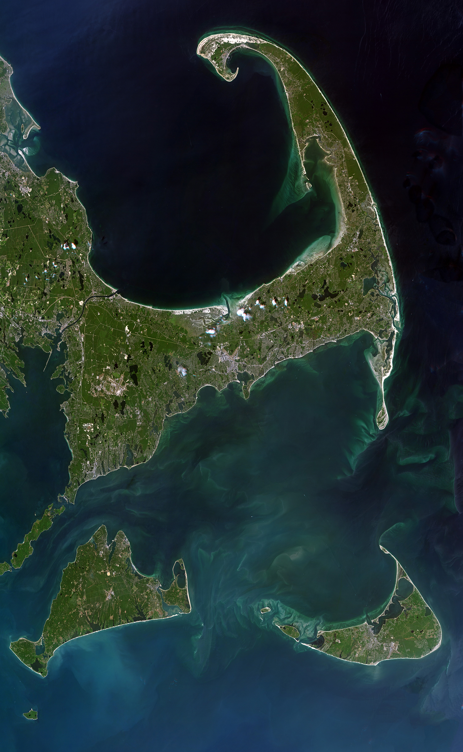
FIGURE 4.
Cape Cod, Nantucket
and Martha’s Vineyard, Massachusetts, U.S., collected July 14, 2012