-
February 3, 2018
An Essential Part of IoT
Energy conservation and sustainability is a priority for governments and businesses in regions throughout the Americas, Europe, Middle East…
7 -
January 31, 2018
Interpreting What We See
Our Perception of an object changes depending on how far or close we are and on how accustomed we…
-
January 31, 2018
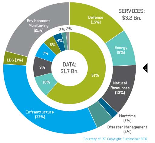
Geospatial Analytics-as-a-Service & Platforms
The field of Earth Observation (EO) has seen two big changes in recent years: first, the massive increase in…
-
January 31, 2018
What’s Next for Imagery Insights Providers?
As the U.S. commercial remote sensing (CRS) industry continues to evolve, there is a secondary, related industry emerging alongside…
-
January 26, 2018

The Power of Imagery Insights and The Overview Effect
Dear Readers,
In this issue, we begin our new series on the emerging imagery insights sector, or Geospatial Analytics-as-a-Service (GaaS… -
January 18, 2018

Geospatial Data Act Exposes Geospatial Community Division
Legislation in congress has exposed a chasm in the geospatial community that could jeopardize chances to reform and improve…
-
October 2, 2017

The Future of GPS
More than half a century after a study by The Aerospace Corporation first laid out the design options for…
-
October 1, 2017

Moving Data at the Speed of Light
The amount of data being collected from satellites is extremely high and continually increasing, putting severe pressure on downlink…
-
October 1, 2017
Open Source GEOSPATIAL SOFTWARE
Open source geospatial software—spatial data management, GIS, and related developer tools and end-user applications delivered with an open source…
-
October 1, 2017

A Killer App for Sats
Ursa Space Systems Inc. (Ursa) is a satellite imagery analytics company whose focus is on commodities and the financial markets….