By Dr. Odean Serrano / National Geospatial-Intelligence Agency / www.nga.mil
Justin Sherin and Terri Ryan / Booz Allen Hamilton / www.boozallen.com
The National Geospatial-Intelligence Agency (NGA), Department of State, and the National Center for Atmospheric Research (NCAR), in collaboration with the World Wide Human Geography Data (WWHGD) Working Group and the Homeland Infrastructure Foundation Level Data (HIFLD) Sub-Committee leadership hosted the Climate and Human Security – Geospatial Data and Mapping Symposium on June 3-4, 2015. The symposium, hosted at the University of Colorado, Boulder, focused on developing collaborative networks, bridging expertise from policymakers to scientists, in order to leverage data and the latest research on climate impacts to human security.
This collaborative meeting brought together over 300 total attendees (138 In-Person and 165 gathering via Webinar) from 157 different organizations across the Department of Defense, Civil Agencies, Academia, Non-Governmental Organizations, the Volunteer Technical Community, and Private Corporations, with international representation from Nigeria, Mexico, Canada and Sweden.
Throughout the symposium, participants discussed climate and human geography data, modeling, collaborative partnerships, data requirements and tradecraft capabilities as well as climate impacts to human security. Climate has only been acknowledged as a human security risk for less than 10 years. Human security requires the attention of many missions, many of which overlap. See Figures 1-2. Specific objectives of this meeting included:
Attaining a better understanding of the working and research dimensions of climate and human security; Increasing knowledge of the challenges of climate prediction and impacts to human security; Increasing awareness of climate data, models and mapping tools; Learning the global extent of current research in key areas; Escalating collaboration, networking, and partnerships.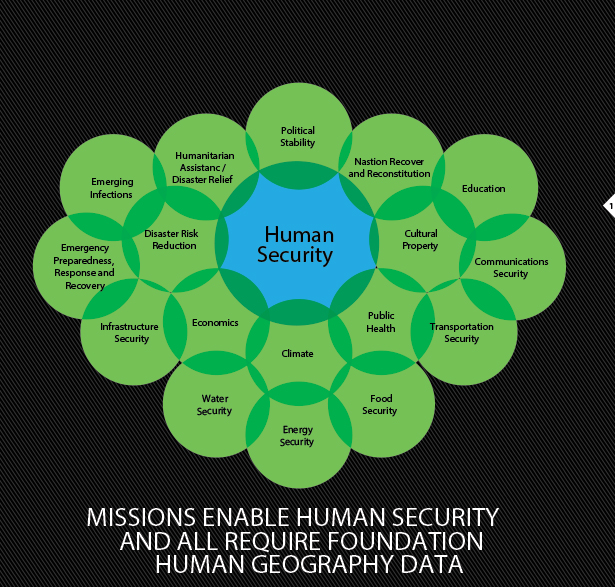
FIGURE 1.
Supporting human security involves foundational human geography data and many missions.
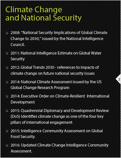
FIGURE 2.
Assessments are integral components, and are required by law. The National Climate Assessment is done every four years, the most recent of which was released in May 2014.
During the symposium, experts in the field of climate and human security participated in panels and facilitated discussions on Climate Risk, Challenges, and Decisions; Global Climate Change – Adaptation and Mitigation Efforts for Human Security; Climate Change and Global Human Security; Climate and Human Security Industry Initiatives; Climate Modeling: Global Human Security Indicators; Anticipating Near-term Climate Disruptions on the Human Geography Scales; Climate Change Demographics; and Health Impacts and Global Climate Change Impacts Research.
Human Security Indicators; Anticipating Near-term Climate Disruptions on the Human Geography Scales; Climate Change Demographics; and Health Impacts and Global Climate Change Impacts Research.
Keynote speakers for the event included: Judge Alice Hill (Ret), of the White House, National Security Council; Robert Cardillo, Director of the NGA; Dr. Lee Schwartz, Geographer of the U.S., Department of State (DoS); John Englander, Oceanographer and author of High Tides on Main Street; and Dr. Ian Noble, Advisor, Notre Dame Global Adaptation Index.
Director Cardilloís opening remarks welcomed the audience to the first Climate and Human Security Symposium comprised of the many stakeholders from policymakers and human geographers to climate scientists, human security practitioners and analysts. Director Cardillo stated that the unique perspective offered by these different groups and collaboration afforded by the symposium will help identify fundamental geospatial data critical to enhancing our understanding of climate change and its implications for society within a Human Geography framework. He emphasized how NGA has made a concerted effort to share Ebola products with the world at large using NGA’s ArcGIS online site as well as through the WWHGD Community on GeoPlatform. See Figure 3. Director Cardillo was pleased that the panelists and attendees are all interacting together to harness our geospatial data and analytic efforts that will address the President’s message that climate is a National Security threat. He closed by stating that this work will help the community to adapt, mitigate and keep the world an environmentally safe place for everyone.
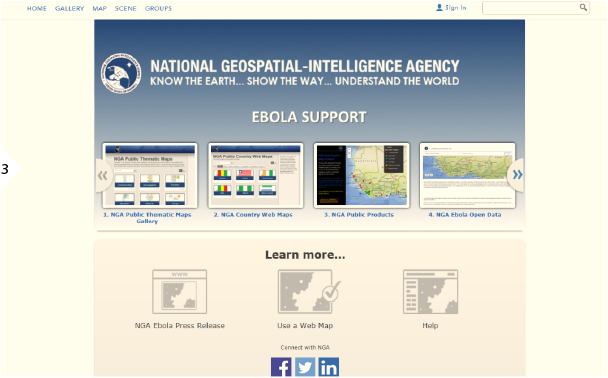
FIGURE 3.
Many agencies and organizations joined forces to share ebola data
and address the issue. See https://nga. maps.arcgis. com/home/.
Judge Alice Hill (Ret) of the White House National Security Council provided the keynote address to commence the symposium. She first noted that her task on the Security Council is specifically related to climate change, and agreed with President Obama’s message that climate change is a fundamental and immediate threat to U.S. national security, and a serious threat to global security. Judge Hill noted that water supply and reliability are at risk as drought becomes more frequent and severe, and that those shortfalls will affect every country on Earth. Judge Hill urged the attendees to continue working collaboratively to develop climate change mitigation solutions.
In addition to the keynote speakers, the symposium included over 30 speakers and panelists who shared their expertise and knowledge on Climate and Human Security. They were passionate about ensuring that the data was at the scale appropriate for decision making. The presenters and audience agreed that there was a need for a bridge of collaboration between the scientists and analysts to the key stakeholders and decision makers.
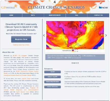
Dr. Odean Serrano of NGA presented the Environmental Geography Community framework that bridges the gap of science and policy by bringing together a variety of environmental security topics, by theme, to include Water, Climate, Food, and Ecosystems. Of great interest to the audience were the climate data sources shared by Dr. Olga Wilhelmi, NCAR GIS Program and Climate Inspector. Dr. Wilhelmi described the Climate Change Scenarios GIS Portal, located online at http://gisclimatechange.ucar.edu. The portal features a new application called the Climate inspector (http://gisclimatechange.ucar.edu/inspector), in which a user can explore climate change anomalies interactively (source code available on GitHub). See Figures 4-5.

FIGURES 4-5.
UCAR offers a Climate Change Scenarios GIS Portal: http://gisclimatechange. ucar.edu/, and an open source interactive web application for exploring climate variabilities and anomalies called Climate Inspector, at http://gisclimatechange.ucar. edu/inspector.
At the closing of the symposium, Mr. Ted Cope, Director of the Office of Basic and Applied Research at NGA; Dr. Lawrence Buja, Director of the Climate Science and Applications Program at NCAR; Dr. Lee Schwartz, Department of State; and Mr. Brian Hagan, National GEOINT Officer for Geography and Cartography at NGA, provided a discussion on the way forward.
Dr. Schwartz highlighted the need to discuss Climate and Human Security topics with policymakers within a short-term and long-term context so that timely decisions regarding climate and humans can be made. Dr. Buja conveyed the climate and human security community needs a mechanism to collaborate with key stakeholders. Mr. Cope discussed how complex the problem is and how integrating location data will help to visualize the magnitude of climate change. He also talked about the need for human security to support national security. Mr. Hagan discussed the need to get data and assimilate data in one place to share and thanked the planning team and all the attendees.
This symposium was the second combined event facilitated for NGA by the World-Wide Human Geography Data Working Group and the Homeland Infrastructure Foundation-Level Data Sub-Committee.
In 2011, the World-Wide Human Geography Data Working Group (WWHGD WG) was created to focus on the need for human geography global foundation data in order to provide a basis for a deeper understanding of cultures, activities, and attitudes for analytics. Well-organized and comprehensive human geography data can be applied to analysis that allows us to better anticipate the behavior of people over space and time and to inform decision-making that supports human security, including crisis mitigation and humanitarian response. The WWHGD WG is designed to build voluntary partnerships around human geography data and mapping focused on the general principle of making appropriate information available at the appropriate scales to promote human security. This involves a voluntary “whole-of-governments” national and international approach to create a human geography data framework that can leverage ongoing efforts around the world to identify, capture, build, share, and disseminate the best available structured and unstructured foundation data. The WWHGD Working Group has over 2600 members from throughout the Department of Defense, Civil Agencies, International Organizations, Non-Governmental Organizations, Academia and Private Industry. Join the WWHGD WG at https://wwhgd.org.
“(We are working) together to harness our geospatial data and analytic efforts that will address the President’s message that climate is a National Security threat.”– Robert Cardillo, NGA Director
The Homeland Infrastructure Foundation-Level Data (HIFLD) Sub-Committee was established in February 2002 to identify, share, and protect geospatial infrastructure data/information used for visualization and analysis. The HIFLD Sub-Committee is a chartered multi-agency organization of Federal partners. HIFLD partners include: the Defense (DoD) Office of the Assistant Secretary of Defense for Homeland Defense and Americas’ Security Affairs – OASD (HD&ASA); the Department of Homeland Security (DHS); the NGA; and the Department of Interior (DOI) United States Geological Survey (USGS) National Geospatial Program (NGP). The sub-committee brings together individuals across the Federal, State and Local Governments and the private sector involved in promoting information sharing, enhancing partnerships, collaboration, sharing best practices and providing an enterprise approach to identifying and developing common authoritative infrastructure data, common processes, and leveraging technology. The group enhances outreach and awareness of the Homeland Security Infrastructure Program (HSIP) datasets (Gold and Freedom) to the HLS, HD and National Preparedness – Prevention, Protection, Mitigation, Response and Recovery (NP-PPMR&R) communities. In recognition of the value that the HIFLD whole of government partnerships have brought to the Homeland Security, Homeland Defense and National Preparedness communities, the Federal Geographic Data Committee (FGDC) has adopted the HIFLD as a sub-committee. Join the HIFLD Sub-Committee at https://www.hifldwg.org.
Both the WWHGD Working Group and HIFLD Sub-Committees facilitate open sharing using both foundational and mission-specific data, advanced geospatial analytical capabilities, and best practices to meet mission objectives and to promote a better understanding of the world around us.
For more information, please visit https:// WWHGD.org or www.HIFLDWG.org to attain copies of the briefs provided during the symposium and the attendee list.