BY MATTEO LUCCIO / CONTRIBUTOR / PALE BLUE DOT LLC
PORTLAND, ORE. / WWW.PALEBLUEDOTLLC.COM
 THE ADVENT OF MASS-PRODUCED, MINIATURE satellites is radically changing Earth observation by vastly increasing the imagery’s “refresh rate.” San Francisco-based Planet Labs is at the forefront of this upheaval, producing, launching, and operating hundreds of spacecraft. The company plans to launch more than 100 satellites and achieve daily coverage of the whole Earth this calendar year.
“As more and more satellites come online, first we will be producing a global basemap, then repeat coverage on a quarterly basis, then on a monthly basis, then on a weekly basis, then on a sub-weekly basis,” says Andrew Zolli, the company’s VP of Global Impact Initiatives. Yet, according to Robbie Schingler, the company’s Chief Strategy Officer and Co-Founder, the next major revolution in geospatial technologies will be on the ground, based on expanded capabilities to exploit that flood of data from space. I discussed the company’s mission, technology, and market strategy with Zolli and Schingler.
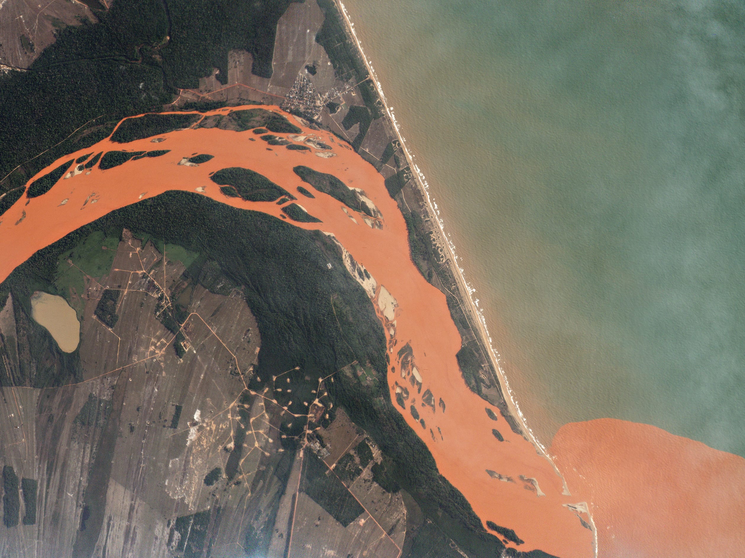
FIGURE 1. In the weeks following the Bento Rodrigues Dam failure in Brazil, which was Nov. 15, 2015, the Rio Doce has carried water contaminated with iron-mining waste 300 miles to its mouth in the Atlantic Ocean. Image: Planet Labs, captured November 29, 2015
PLANET LABS’ MISSION
Zolli was first exposed to Planet Labs in the early stages of its development. With the help of a founda- tion, he recalls, the company convened a group of thought leaders in humanitarian, social, and ecological innovation to explore what its imagery might mean for the way we address global challenges. “It was immediately clear to all of us that the company’s data, tools, and platform could be an absolute game changer,” he says. “I was especially blown away by the potential to democratize access to this kind of imagery, to get people directly engaged in stewarding the planet.” (See Sidebar on Planet Labs’ commitment to addressing global challenges via “Open Regions” below)

Planet Lab’s mission is to image the whole Earth, every day, and make global change visible, accessible, and actionable. The company, Zolli explains, is at the forefront of three revolutions:
a space renaissance, characterized by a new generation of space-oriented companies; a global sensing revolution, characterized by the deployment of vast arrays of sensors to detect change on the planet at scale; and a data and analytics revolution, which is making vast quantities of data available to be combined, analyzed, and turned into useful insight.
FIGURE 2. Canterbury, New Zealand. The Rakaia River carries glacial runoff through pastureland and into the Pacifc Ocean. Image: Planet Labs, captured March 26, 2016.
“Planet Labs participates in all three of these. We’re deploying the largest constellation of Earth- observing satellites in human history; when fully operational later this year, our constellation will capture the entire terrestrial surface of the Earth, every day, at a resolution of roughly 3m per pixel. Then we’re bringing that data to the Web via a platform and API, so that anyone can get access to it.”
Unlike traditional approaches to geospatial imaging, he says, his company is not a tasking-oriented service. “We are not pointing satellites, we are not turning them on for discreet periods of time when they are focused on a particular patch of Earth. Instead, Planet Labs is delivering a persistent monitoring mission—seeing every- where, every day.”
This approach yields not only imagery of what the Earth looks like in its totality on a given day, but also evidence of unfolding changes in nearly real time, and indicators of coming change. “That has enormous economic value, as you might imagine,” says Zolli. “At the same time, we’re also able to see the spread of droughts, the variation in agricultural yields, and the roads that are built before illegal deforestation occurs. In the right hands, these indicators can be used to save our fragile ecosystems, improve global food security, and save lives.”

FIGURE 3. Dove satellites capture growing sugar cane fields in Brazil’s southernmost state, Rio Grande do Sul. Image: Planet Labs, captured March 16, 2016.
SPATIAL RESOLUTION VS.
TEMPORAL RESOLUTION
The temporal resolution of Planet Labs’ imagery will be daily and its coverage is global. Therefore, Zolli points out, it is not sufficient to simply compare Planet Labs’ 3-meter/pixel imagery to higher spatial resolution imagery and ask which one is better. “Each has its applications, and, interestingly, they might find their best use together.” A daily refresh rate, for example, is especially good for monitoring for change, while a higher-resolution, task-based sensor can yield a very useful image if you know where to look. Originally indicating the number of times in a second that a display hardware updates its buffer, “refresh rate” is increasingly also used to refer to the time between two images of the same geographic extent taken by the same sensor system. “Planet Labs’ imagery is especially good for detecting high-level change and figuring out where to look,” says Zolli. “The two can work together.”
In other cases, Planet Labs’ “deep stack” of imagery is essential, because it allows users to see what a place looked like just before a radical change, such as a natu- ral disaster, Zolli points out. In most cases, the company is likely to have the most recent pre-disaster imagery for any given place on the planet, which is hugely important in understanding what buildings have been knocked down. Likewise, in the case of forest fires, a “deep stack” of imagery helps monitor a fire’s progress. Therefore, the temporal resolution of the company’s imagery is at least as valuable as its spatial resolution.
BUSINESS MODEL AND ACCESS TO THE DATA:
THE PLANET PLATFORM
Planet Labs sells its data to private companies, public institutions, national and local government agencies, and international institutions. “Many organizations in such areas as precision agriculture, forest monitoring, or insurance have a strong interest in our data,” says Zolli. Planet Labs is also introducing a cloud-based platform to provide direct access to it imagery. “Soon, you’ll also be able to upload your own datasets and run your own analytics on top of our platform,” he says.
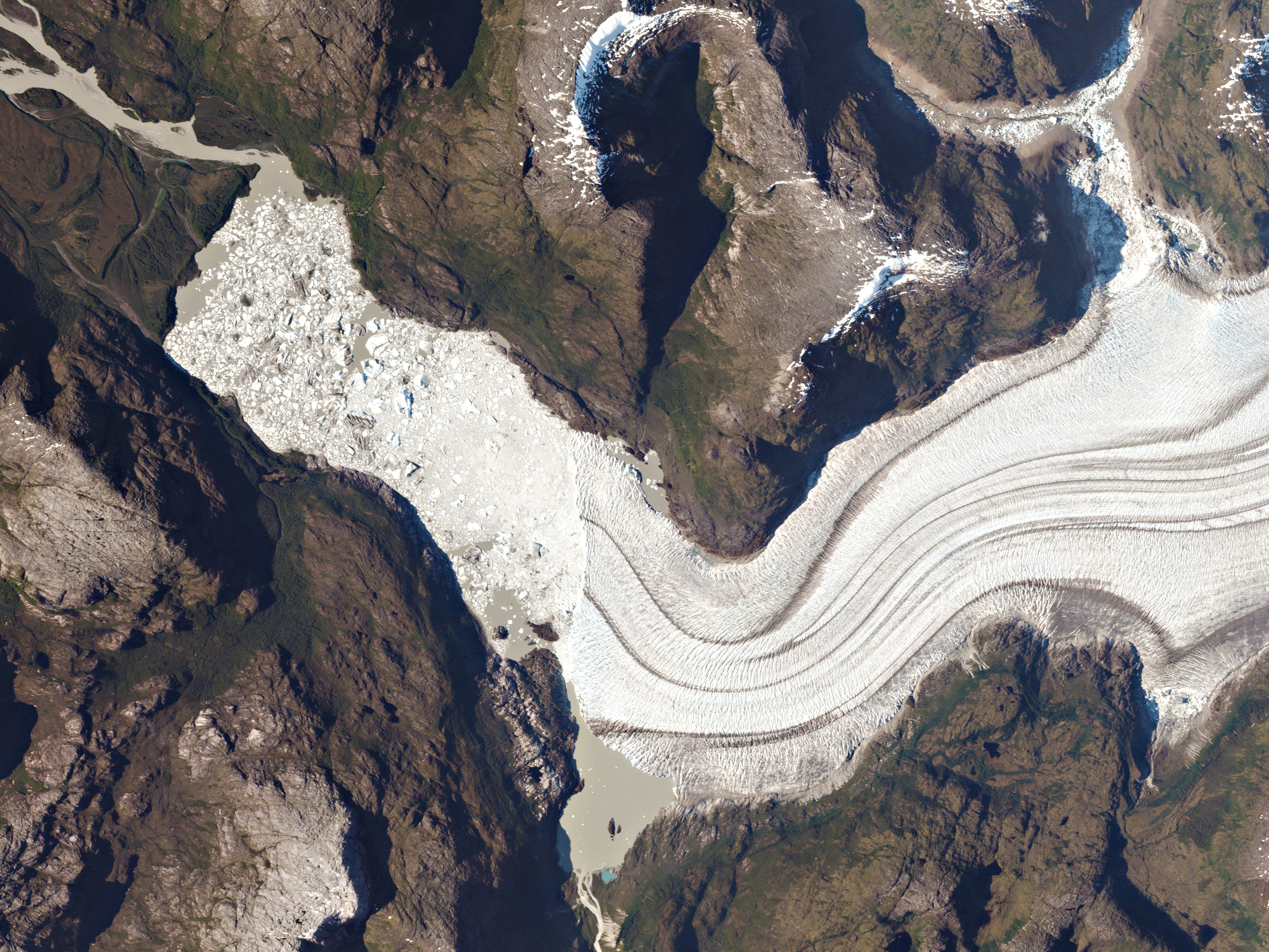
FIGURE 4. Massive icebergs and an ice mélange ll the lake at the toe of Occidental Glacier Bernardo O’Higgins National Park, Chile. The glacier drains the Southern Patagonia Ice Field. Researchers use Planet’s frequent, wide-area imagery to monitor and measure glacial movement and melt. Image: Planet Labs, captured January 10, 2016
The company sees this cloud-based platform as transformational. Historically, Zolli explains, the humanitarian and social impact organizations that could most benefit from this kind of data were the least likely to be able to access it due to the cost and the technical proficiency it required. A cloud-based platform, however, requires neither an in-house geospatial team nor large data purchases. “We are making this available for the masses and will bring many millions more people and organizations into the user community,” he says.
At the same time, advanced analytics compa- nies are beginning to use the company’s data in new ways. For instance, a machine-learning and computer vision company called Descartes Labs used them to reveal an error in U.S. government forecasts of U.S. corn production, and another company is using them to study China’s economic productivity. “This ability to produce new kinds of indicators is going to have a huge impact on the way we solve problems in the future,” Zolli predicts. With regard to such problems as public health, climate adaptation, poverty alleviation, and urban resilience, he explains, a reliable signal is a prerequisite for effective action.
Last year, Planet Labs acquired BlackBridge, which operated its own constellation of satellites, commonly called RapidEye. It then integrated BlackBridge’s repository of Earth observation data into its
platform, which also contains datasets from Landsat and from Planet Labs’ Dove constellation. “In addition to this,” says Zolli, “BlackBridge brought real depth of experience in certain markets. For instance, they were a significant player in the REDD and REDD+ markets, in which geospatial data is used to reduce deforestation and forest degradation.”
IMAGERY FOR AGRICULTURE
While about 90 percent of farmed areas in the United States are covered by a federal crop insurance program, in many developing countries, two-thirds of the food is grown by so-called “small-holder” farmers.
They work at near subsistence levels on informal plots of land that are often just a fraction of an acre. This makes it impossible to provide them crop insurance, Zolli explains, because it’s hard to see what’s happening on the ground for them. “While their labor costs are very low, their exposure to such things as climate change is very high. If there is one significant drought event, they could easily be pushed off of their land, which would be a calamity not just for them but also for the many people that they feed.” Planet Labs’ satellites, in conjunction with small ground weather stations, could play an important part in making crop insurance feasible at scale in vast areas of the world where it is not yet feasible, Zolli says.
WEATHER DATA
Weather has a huge impact on many facets of society, especially due to climate change. Traditional weather satellites are very large, carry up to a dozen sensors, weigh thousands of kilograms, take up to ten years to build, and are very expensive. Planet Labs has proven the ability to build very capable Earth imag- ing sensors that are two orders of magnitude smaller (this drastically reduces the total mission cost, which is mostly due to getting the satellite into space) and autonomously operate them, says Schingler. “You don’t necessarily need to create a spacecraft that looks like a Christmas tree. You can actually throw the individual ornaments up themselves.”
Launching much cheaper, single-sensor weather satellites that can be mass produced quickly would provide a higher temporal capability than the current generation of satellites, Schingler points out. “I think that there is an opportunity for other companies to do for the weather market what we have done for electro-optical and near-infrared capabilities for Earth observation. That torrent of data will then allow people to make better decisions, based on the changing weather around them.”
The commercial weather market today is analogous to that of remote sensing 20 years ago, Schingler argues: people are used to getting weather data for free from a few major governments around the world. Therefore, commercial weather companies have to both create and serve a new market.
GETTING IMAGERY DOWN TO EARTH
Planet Labs’ business model and operational set-up do not include live streaming of data from space. The company’s satellites operate in a store-and-forward manner: they are constantly capturing and compressing data, then transmitting them whenever they are over ground stations. These stations, in turn, send the data to the company’s cloud servers, which decompress them, calibrate them, orthorectify them, and make them available to end users via a Web-based API.
Streaming data from space can be done in several ways. One is to transmit them directly down as they are captured. However, that requires ground stations everywhere. An alternative is to beam the data up to a telecomm satellite that then transmits them down to the ground. However, that is very expensive, because it requires having many satellites in your network. “A third architecture,” Schingler explains, “is to have your satellites talk to one another, because odds are that you will have a spacecraft that is looking at a ground station.”
Current real-time feeds from space include some from satellites in a geostationary orbit, such as weather satellites. They send updates every 15 minutes but at very coarse resolution, because they are so far away. The International Space Station can stream data from its cameras because it is always connected to NASA’s telecomm satellite, the Tracking and Data Relay Satellite L (TDRS-L), which then transmits this near real-time feed of the planet down to ground stations.
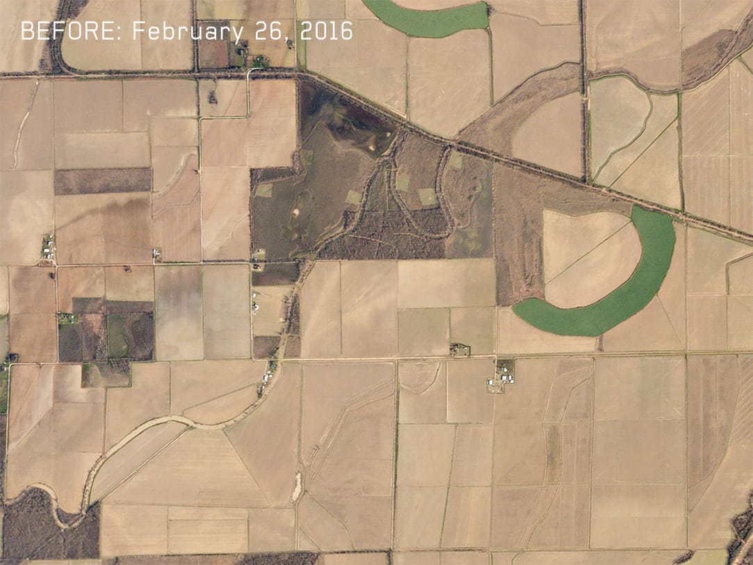
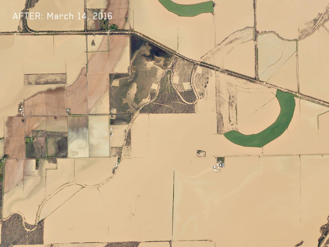
FIGURE 5-6. Louisiana Flooding. A slow-moving storm in March, 2016, caused severe flooding in the southern United States. Just outside of Oak Grove, Louisiana, nearly 24 inches of rainfall has flooded the Boeuf River, engulfing roads, fields, and homes. Courtesy Planet Labs.
THE NEXT BIG THING
“The next big thing for geospatial,” says Schingler, “is in multi-source data fusion capability on Web- based platforms, using streaming information feeds, and bringing to bear against geospatial data a variety of computer vision and machine vision learning algorithms that have primarily been developed by large IT companies over the last half decade.” That, he argues, will increase by orders of magnitude the number of users who can consume geospatial data and information services derived from this information feed—including many users of business intelligence and decision support tools who are not GIS experts. “The next major revolution will be on the ground, with data exploitation and the ability to build
sustainable businesses on top of the unique information feed that comes from space and to match it up with data collected on the ground.”

FIGURE 7. Greenbelts and agricultural fields hug the shores of the Itaipu Reservoir – a natural border between Brazil and Paraguay. The area’s warm, tropical climate makes it an ideal place to grow sugar cane, coffee, tea, and cotton. Image: Planet Labs, captured January 27, 2016.
Because Planet Labs’ satellites are collecting imagery continuously and will soon be refreshing their complete Earth coverage daily, users no longer need to be experts about the satellites’ capabilities. His company, Schingler says, wants to give people the ability to see global change and access that information via their mobile platforms. “Once that market grows a lot, then we’ll see again an explosion of new sensors in space to meet users’ needs.”
Zolli believes that in the future we are going to see countless new applications for his Earth observation data. For example, the framework agreement on climate change signed last December at the UN Global Climate Summit in Paris calls for putting a price on carbon, which requires functioning carbon markets. “We believe Planet Labs’ data is going to be an important tool for underwriting the success of those carbon markets,” he says. “We are building a platform on which there will be many, many applications, including some that we ourselves cannot foresee.”
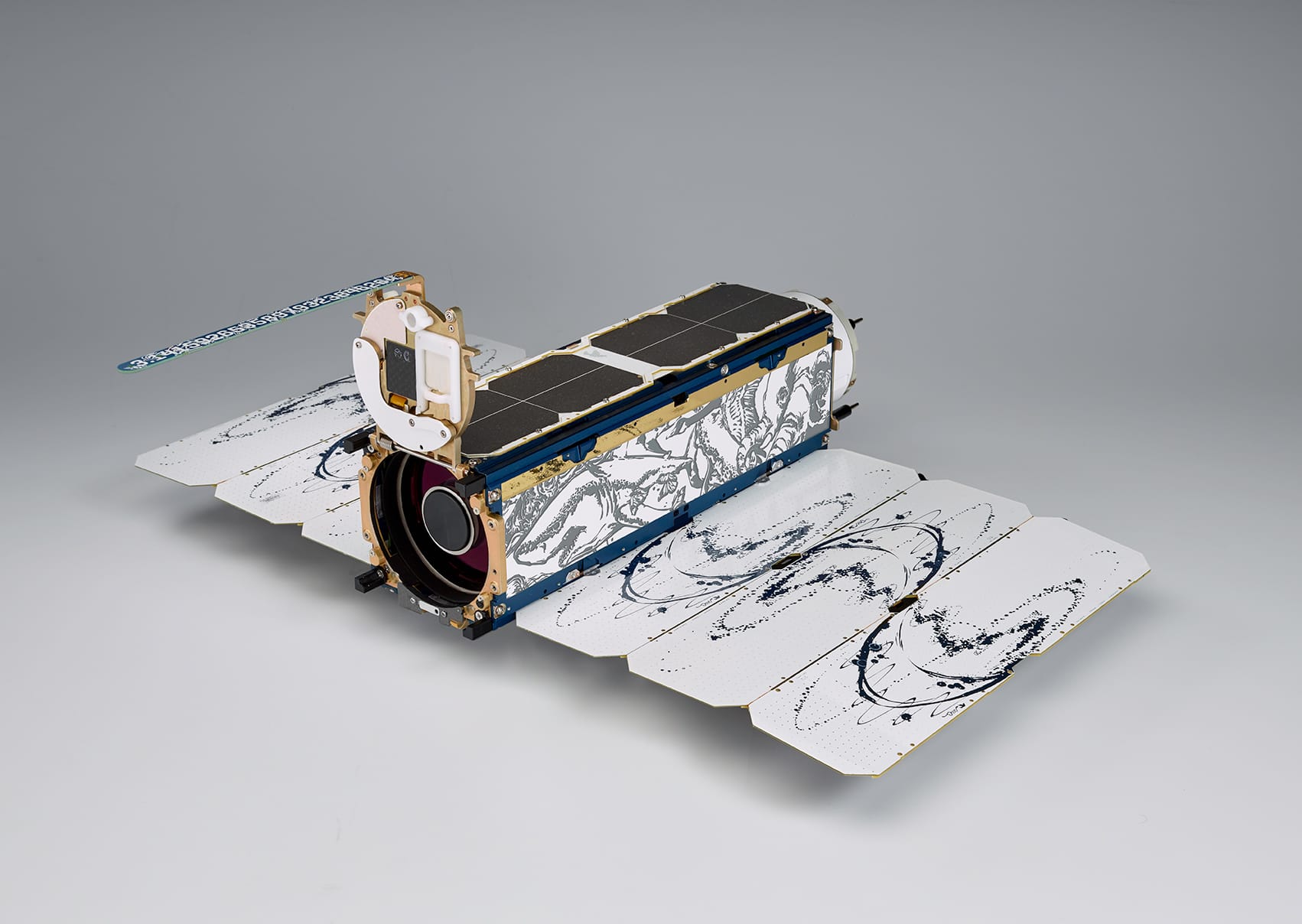
FIGURE 8. Dove satellites measure 10x10x30 centimeters. It will take 120 satellites orbiting in a Sun Synchronous Orbit to image the Earth’s entire landmass every day. If current launch schedules hold, Planet Labs will reach this on- orbit target by the end

FIGURE 9. The founding team of Planet Labs in the garage with a Dove satel- lite. From left to right: Robbie Schingler, Chris Boshuizen, Nato Saichek, Mike Vlahos, Mike Safyan, Will Marshall, Matt Ferraro, and Ben Howard.
