Sustainability is a relatively recent concept intro- duced in the 1980s and defined by the United Nations World Commission on the Environment and Development in 1987 as “development which meets the needs of the present without compromising the ability of future generations to meet their own needs.” This definition did not satisfy everyone, and other definitions arose. Gradually, it became clear that sustain- able development is not a concept of a strictly scientific nature that can be defined without ambiguities; opinions differ on what precisely should count among the human needs for the application of the principle of intergenerational equity. These needs can be
categorized into the social, economic, and environmental realms, but the relative importance of the different components is a matter of opinion.
Sustainable development is these days a meeting point for the debate about the state of the world and how to respond to the social, economic, environmental, and institutional challenges we are facing. We are still very far from achieving it but we can identify the main drivers of unsustainability, which can be organized into four leading groups. Space systems play a crucial role in addressing the problems raised by these four groups of drivers, which constitute the “square of unsustainability.” See FIGURE 1.
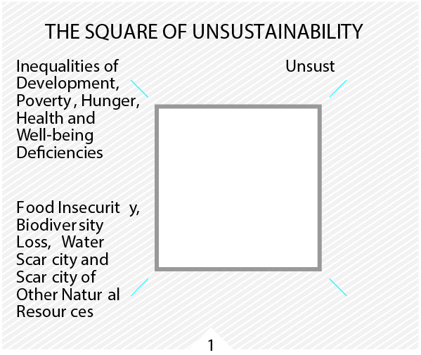
FIGURE 1.
The Square of Unsustainability—a way to look at the issues that need to be addressed.
The first group plays a prominent role among the others and includes the inequalities of devel- opment, poverty (especially extreme and severe poverty), hunger, and health and wellbeing defi- ciencies. The second group encompasses food insecurity, biodiversity loss, and scarcity of water and other natural resources.
The third, sustainability of energy systems, requires secure access to energy sources, affordable pricing and environmental compatibility. This last criterion is not satisfied by fossil fuels, which represent about 80% of the world primary energy sources, because their combustion leads to the emission of CO2, a greenhouse gas.
Finally, the fourth driver is anthropogenic climate change, mainly due to CO2 emissions from fossil fuel burning and to land use changes, especially defores- tation. All four groups of drivers are strongly interconnected and interdependent. To reach some form of sustainable development, these issues must be addressed in ways that are both simultaneous and integrated. The magnitude and difficulty of this task reveal the perilous state the world is in.
Inequalities of Development, Poverty, Hunger and Health
Since World War II, a remarkable acceleration in social and economic development worldwide has occurred, lifting hundreds of millions of people out of poverty and improving the quality of life of many more. However, poverty is still very significant and a major impediment on the way to sustainable development.
According to World Bank statistics, about 50% of the world population live on less than $2.50 a day and about 80% on less than $10 a day. People living in poverty in the developing countries are focused on survival and therefore give a low priority to environmental problems. Furthermore, inequalities are increasing worldwide. More than 80% of the world’s population live in countries where income differentials are widening.
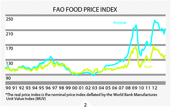
Poverty is the main cause of hunger. According to the United Nations Food and Agriculture Organization (FAO), the number of hungry people has increased since 1995-97 and reached a peak of 1.02 billion in 2009. In 2010, it decreased to 925 million, which corresponds to 13.1% of the world population, or almost one in seven people. One of the main reasons for the recent trend in malnutrition is the increase in food prices since 2004, with major peaks in 2008 and 2011. See FIGURE 2.
Food prices are increasing for many reasons. One of them is climate change, which leads to more frequent weather and climate events such as droughts, floods and storms, and thus to crop failures. A further reason is the competition between energy and food through the cultivation of biofuel crops, which may take valuable farmland out of food production.
Also, the global population is growing too fast for agricultural production to keep up. In the developing countries, particularly in those with emerging economies, citizens are consuming greater quantities of higher quality food, which is a very welcome development but requires more water and energy, along with good quality soils. The rising price of oil makes it more expensive to produce and ship food products. Finally, food prices are increasing because of decades of neglect of agriculture, especially in hunger-prone regions.
“Space activities contribute decisively to the well-being of humanity and to sustainable development.”
To increase the global food production in a sustainable way, an improved management of the world’s agricultural resources is required. To achieve this goal, satellite imagery data must be used at different spatial, spectral and temporal resolutions. Space systems applications can be used for sustainable agricultural management and development, crop system analysis, integrated agricultural drought assessment and management, and assessment of land productivity and soil carbon dynamics.
A notable application of satellite data is the Famine Early Warning System Network, which was initially set up in Sub-Saharan Africa and now operates in other arid environments in developing countries. This system uses satellite images in conjunction with ground-based information to predict and mitigate famines.
According to the United Nations World Health Organization, water scarcity already affects every continent and 40% of the world population. The situation is getting worse because of population growth, urbanization and the increase in domestic and industrial water use. By 2025, nearly 2 billion people will be living in countries or regions with absolute water shortage, where water resources per person fall below the recommended level of 500 cubic metres per year, the amount of water a person needs for healthy and hygienic living.
Satellite imagery data are increasingly used for water resources monitoring and development plans. Satellite applications can measure rainfall, water movement and the height of water in rivers, lakes and wetlands. They can also serve to identify surface and underground water resources in drought-prone regions.
In the health sector, the inequalities among countries are growing at an alarming rate. Life expectancy, for instance, varies from less than 45 years in some sub-Saharan countries to more than 80 years in some OECD countries (Organization for Economic Cooperation and Development). The reasons for this profound disparity are well known: poverty, lack of adequate health infrastructures and medical services, lack of or inefficiency in the control of epidemics, and insufficient financing of pharmaceutical and medical research or the specific diseases of the tropical regions, where many of the developing countries are located. Satellites are essential tools in providing clinical health care at a distance through telemedicine. This technology improves the access to medical services in distant rural communities and also in emergency situations.
DEFORESTATION MEASUREMENT
Environmental monitoring using satellites has expanded widely in the past few years, and this trend is expected to continue. A very important example is the application of satellite imagery for forest monitoring and conservation. Deforestation began with the emergence of agriculture, which is responsible for a 20–25% reduction of the global forest area.
It is very difficult to make a precise assessment of the historical evolution of forested areas on a regional and global scale because different definitions and concepts of forestry have been used and because the quality of the data has a strong spatial and temporal variability.
Currently, the situation has greatly improved through access to remotely sensed data, which provides a much more reliable form of monitoring.
According to FAO, around 13 million hectares of forest were converted to other uses or lost through natural causes each year between 2000 and 2010, in addition to 16 million hectares per year during the preceding decade. This results not only in biodiversity loss, but also contributes 12-15% to global warming by releasing CO2 into the atmosphere and hampering further CO2 storage.
Currently, the forests in the temperate zones of North America and Eurasia have stabilized or are increasing, while the tropical forests continue to decline. Using high-resolution satellite images, it has been possible to estimate that the average annual rate of tropical forest destruction between 2000 and 2005 was 5.4 million hectares and that about half of the deforested land is located in Brazil. See FIGURE 3.
About 60-70% of deforestation in the Amazon is the result of clearing for cattle pasture. Next is small- scale subsistence agriculture, construction of infra- structures, and large-scale commercial agriculture. By combining hundreds of images from satellite coverage with software analysis, experts can analyse patterns of deforestation down to a single tree and calculate the emissions resulting from removing trees that would otherwise sequester carbon dioxide.
The Millennium Ecosystem Assessment published in 2005 reports that the ecosystems have declined more rapidly and extensively over the past 50 years than at any other comparable time in human history. Left unchecked, this degradation jeopardizes the world’s biodiversity and becomes a significant risk factor in business development and a threat to long- term economic sustainability. Satellite imagery is used to monitor and analyse habitat change and therefore to monitor ecosystems and biodiversity.
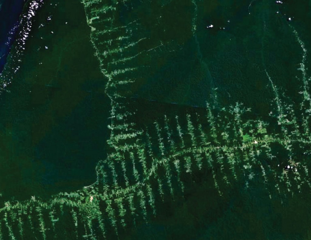
FIGURE 3.
Deforestation in the Amazon seen from satellite,
showing the roads in the forest with a typical “fishbone” pattern,
taken Sept. 20, 2006. Source: NASA.
CLIMATE CHANGE
Climate change is one of the major environmental risks facing humanity in the 21st century. The scientific community has reached a strong consensus that anthropogenic emissions of greenhouse gases are intensifying the natural greenhouse effect in the atmosphere. These emissions are causing a climate change that will very likely intensify during the 21st century. The signs that this climate change is happening are becoming ever more obvious and unequivocal. According to the Intergovernmental Panel on Climate Change (IPCC), the global average surface temperature (land and ocean) has increased by 0.8° C since preindustrial times and by 1.0° C over land alone. In the Arctic, the average surface temperature increase has been higher, about twice the global value.
All 10 years with the highest average surface temperature from 1850 up to 2012 have ocurred since 1998. While 2012 was the ninth warmest year, 2005 and 2010 ranked as the hottest years on record. The ice sheets are losing mass, glaciers are shrinking globally, sea ice cover is reducing in the Arctic, and snow cover is decreasing and permafrost is thawing in the Northern Hemisphere. Ice is being lost from many of the components of the cryosphere, although there are significant regional differences in the rates of loss.
The temperature of the upper ocean layer down to 75 m is increasing more than 0.1° C per decade. More than 90% of the extra energy stored by the Earth between 1971 and 2010, as a consequence of the increased greenhouse effect, has gone into ocean warming. As a result of thermal dilatation, melting of mountain glaciers and, to a lesser extent, melting of the polar ice sheets, global average sea level is rising. It increased between 14 and 20 cm in the 20th century and is presently increasing at an annual rate of 2.7 to 3.7 mm. Climate models indicate that mean sea level will continue to rise at increasing annual rates, reaching a value on the order of 0.5 to 1.4 m, relative to pre-industrial times,at the end of the 21st century.
EXTREME WEATHER INCREASE
In addition to the temperature changes and the rising sea level, another very important aspect of anthropogenic climate change, which has a strong potential impact in many human activities and socio-economic sectors, is the increase in the frequency and intensity of extreme weather and climate events. There are clear indications that the percentage of very strong tropical storms, such as the recent Hurricane Sandy in the North Atlantic, is increasing. See FIGURE 4.
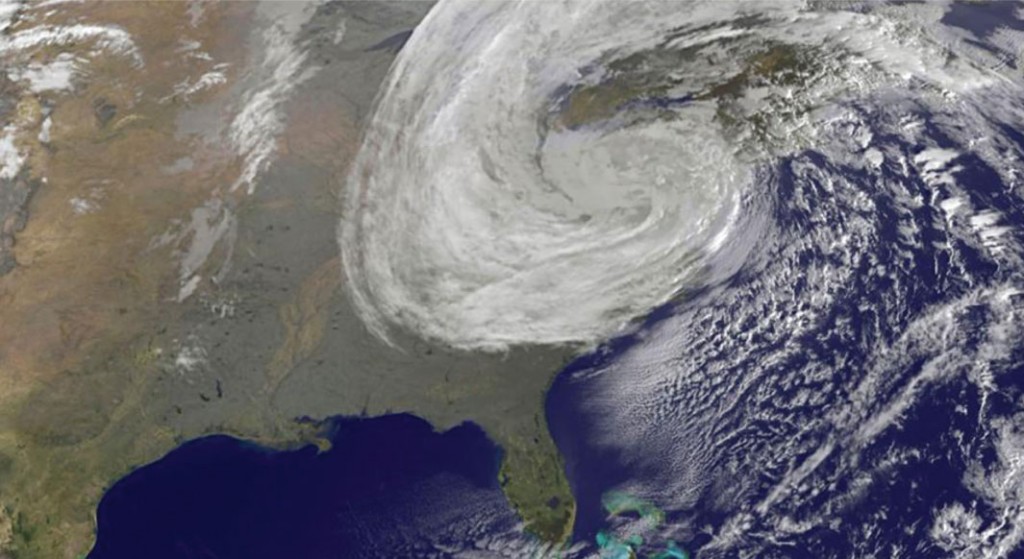
FIGURE 4.
Hurricane Sandy, October 28, 2012. Source: NASA.
Earth observation from space over the past 50 years has fundamentally changed our understanding and knowledge of the Earth system. See FIGURE 5. With increasingly sophisticated space systems, it is now possible to obtain quantitative measurements of temperatures in the atmosphere, concentrations of atmospheric gases, precipitation and wind speed, elevations of land and water, water movement, types of soils, and vegetation cover. In addition, satellite observations yield continually updated knowledge of the state of the atmosphere, helping meteorologists to devise models that project the weather into the future with much improved accuracy compared to pre-satellite forecasts. Seven-day forecasts have more than doubled in accuracy over the past three decades, particularly in the Southern Hemisphere.
Satellites have been used to monitor the stratospheric ozone layer, which blocks damaging ultra-violet light from reaching the Earth’s surface, and to monitor atmospheric aerosol loading. Furthermore, they have contributed decisively to improvements in our understanding of the climate system and of climate change, through monitoring of the atmosphere, sea and land surface temperatures, ice sheet floes, Arctic sea ice extension, the El Niño-Southern Oscillation, and Earth’s carbon cycle. Recently, an ensemble of satellite altimetry, interferometry, and gravimetry datasets has been used to conclude that, since 1992, melting of the polar ice sheets has contributed, on average, 0.59 mm to the annual rate of global sea level rise.
Extreme precipitation and floods are very likely to become more frequent because of climate change. Floods are just one example of various types of disasters where satellites are very useful for humanitarian relief, rapidly mapping and assessing local emergency situations and reconstruction activities. Space systems are extensively used these days in the management of disasters related to geophysical, meteorological, hydrological and climatic events. The uses of satellites in disaster management are becoming more integral to reducing reaction time and to providing accurate information for rescue and disaster control operations. Satellites are very useful in disasters for communications, remote sensing and mapping. Meteorological and storm warning satellite technology can also help in predicting water-related disasters and in setting up precautionary activities.
Many more examples could be given of the importance of space systems for sustainable development. Satellites are currently indispensable to our way of life. One day without civilian satellites would bring chaos to the global human society. Some of the consequences would be the loss of GPS, cell phones, internet access, all traffic control, and access to financial markets, as well as a severe impairment of most weather forecast services. For longer periods of time, the loss of satellites would bring the collapse of civilization as we know it. It is therefore of the utmost importance to guarantee the long-term sustainability of outer space activities.
Water scarcity already affects every content and 40% of the world population… By 2025, nearly 2 billion people will be living in countries or regions with absolute water shortage, where water resources per person fall below the recommended level of 500 cubic meters per year, the amount of water a person needs for healthy and hygienic living.
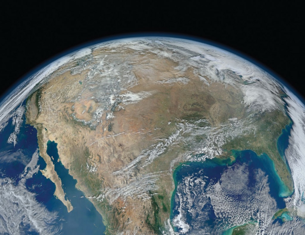
FIGURE 5.
Satellite map of North America. Source: NASA.

