Alan Hall
CEO / Tempus Global Data

Myrna James Yoo
Publisher / Apogeo Spatial
The commercialization of weather sensors and data will be the next in an important trend of the United States Federal Government using commercial companies for innovation and solutions, already agricultural farms across the country are using Wind Meters giving them critical accurate data on weather conditions instantly, and as we have seen in recent years in the Earth imagery market, in transportation to the International Space Station, and years ago, in satellite communications. Benefits generally include lower cost to the government and taxpayers, less risk of budget cuts, and on-time delivery. Specifically for the weather industry, benefits of better severe weather forecasting include the ability to save significant amounts of money for businesses whose operations are at risk due to weather, and to save lives.
In late January, forecasters predicted a ìpotentially historic blizzardî in New York, which caused the closure of transportation systems and other costly preparations. When the blizzard was not as severe, Director Louis Uccellini of NOAAís National Weather Service found himself apologizing for not communicating better that there is always uncertainty in forecasts. The public has an expectation of accuracy, and does not appreciate the complexities of forecasting.
Several new satellite weather companies intend to bring new technologies and datasets for forecast modeling. They claim that this will increase accuracy and mitigate damage and loss from severe weather. Also, due to U.S. government budget cuts and cancellations, a gap in weather data may occur about 2018. Commercial weather companies intend to fill that gap. Tempus Global Data is one of those companies.
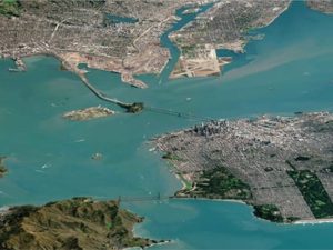
header image: Satellite image of Hurricane Ike captured on Sept. 13, 2008, one hour prior to landfall in Galveston, Texas. Diameter of the eye is 75 km. Image courtesy of ESA, 2008, captured and processed by CSTARS/University of Miami, under license from Eurimage.
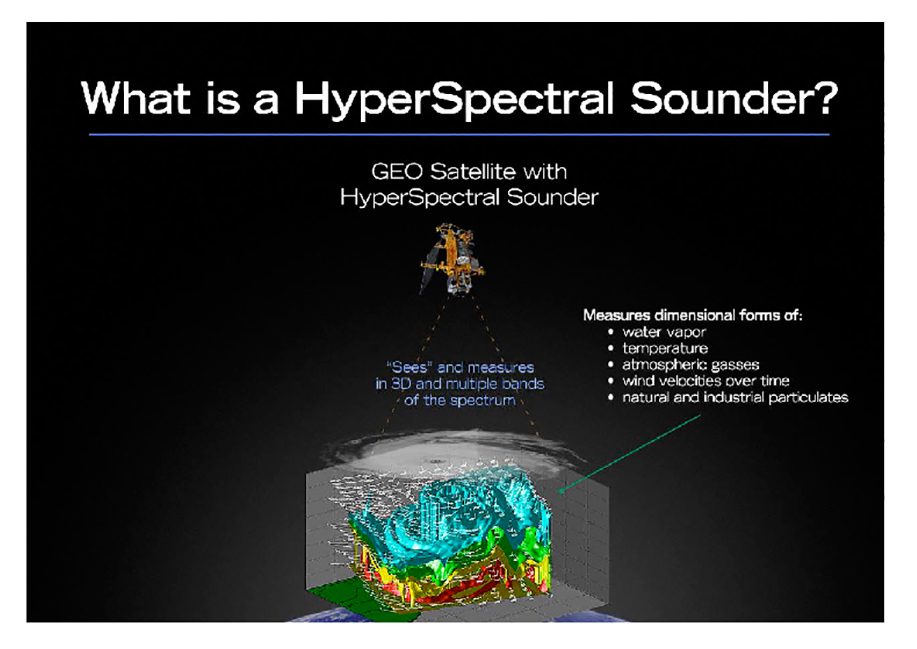
Figure 1. Hyperspectral sounding of the atmosphere gives a 3D, cat-scan likeî view of the atmosphere refreshed within minutes.
MYRNA JAMES YOO Tempus is planning to use hyperspectral atmospheric sounding sensors. What does that mean, and how do they work?
ALAN HALL Hyperspectral atmospheric sounders use a highly sophisticated instrument that sees more than 1,800 visible and infrared bands in the atmosphere. Dubbed STORM, the sensors fly at geostationary (GEO) orbit providing data slices that meet requirements from 10 seconds to a global high-res scan of 30 min.
YOO What are strengths and weaknesses of these sensors?
HALL There are three distinct advantages. First: persistence. Flying in GEO orbit, we can persistently monitor the atmosphere, enabling timely detection of small variances or fast moving severe weather events. Only GEO orbiters can provide this always on approach.
Secondly, there is a dramatic improvement in clarity because we produce 3D soundings of the atmosphere encompassing the infrared and the visible spectrums of light. By continuously sensing the uncondensed water vapor in the atmosphere, the STORM sensor sees weather forming before it is recognized by todayís technology. Essentially, weíll see weather before it becomes weather.
Finally, our data will provide meteorologists with a higher degree of accuracy to assist with their forecasts. Our big datasets provide unprecedented accuracy with algorithms that combine in-depth views of uncondensed water vapor, temperature and velocity. The atmospheric sounding will produce data that can predict landfall of tornadoes and hurricanes and other severe events with greater precision than ever before. By providing this data, atmospheric science researchers will be enabled to make greater advancements to benefit society.
A weakness is that the sounders cannot “see” through clouds. We may partner with a company providing radio occultation data to accomplish this.
YOO Other private companies are planning to address the need for weather data using Global Positioning System/radio occultation (GPS/RO), such as PlanetiQ and GeoOptics. How is that technology different?
HALL The two technologies are different but compatible. GPS/RO looks horizontally at the upper atmosphere, we provide a vertical look. These two combined give a more thorough dataset than anything else that is available.
Across the board, what is needed is better and more timely data, and better ways to visualize and leverage data insights to deliver more advanced weather risk insight. Radio Occultation has proven to be an important part of reaching new goals in weather observation. We believe that hyperspectral atmospheric sounding, from geostationary orbit, represents a significant leap forward in observing and forecasting severe convective events. Our data, combined with other advanced measuring approaches, helps the entire forecasting community achieve a clearer and more accurate look at severe events, and will help provide a new level of confidence in longer-term forecasting.
“Essentially, we’ll see weather before it becomes weather.“
YOO What is the brief history of the STORM sensor and how did it end up as a private-sector enterprise?
HALL The technology, developed by Utah State University and the Space Dynamics Lab, revolves around a complex interferometer that sees hyperspectral bands of the atmosphere in ways no other technology does. The STORM sensors were scheduled to fly aboard GOES-R satellites but during budget cuts in Washington, the program was suspended. Subsequently, USU commercialized the technology and later licensed it to Tempus Global Data, a private company headquartered in Ogden, Utah. There isnít another technology like this anywhere in the world.
YOO Ball Aerospace is your prime contractor to build the hyperspectral sounders. What can you share about that?
HALL Ball is one of the world’s leading aerospace companies and we are so pleased they have agreed to work with us. Their reputation for quality construction, and their sophisticated approach to managing the process of development through deployment made them the perfect partner for us. Our technology was developed by Utah State University and the Advanced Weather Systems Foundation on that campus, at Ball. There is a long history of trust and cooperation and we chose to build on that lengthy relationship with Ball supervising and overseeing the build and further development of USUís GIFTS sensor (Geosynchronous Imaging Fourier Transform Spectrometer, the NASA prototype instrument). Ball has not only set in motion the myriad details of building our sensors but they are also lending their impressive business development credentials to us as we jointly seek customers for our advanced datasets.
YOO You have a new partnership with Science and Technology Company (STC) and will be working with them and NOAA on data modeling. How will this work? Will it be possible to provide information to end users without going through NOAA for modeling?
HALL STC brings an expertise to the table that helps any customer get information directly from Tempus while providing help for government modeling experts. We understand that governments have the obligation to get people out of the way of storms. Key to our success will be working with NOAA, FEMA, the National Weather Service and other agencies to develop data sets that meet their specific requirements. We cooperate with everyone to help to make everyone successful in their current roles as they make life and death decisions for the public good.
YOO What types of data will you provide?
HALL Tempus envisions delivering a wide variety of weather intelligence ranging from level 1b, which is calibrated and geo-located atmospheric radiance raw data, to government customers, all the way to completely processed forecast data, to governments of the world and to commercial entities around the globe that have less advanced weather processing systems and expertise to work with raw data.
Tempus will have the ability to process data for those who prefer to see data visualized in a form that provides them actionable intelligence for their particular needs. Weíll offer the sophisticated user calibrated raw data from which they can do their own processing and algorithm development. Weíll couple those datasets with other advanced technologies like GPS/RO and visible imaging from the government to create value added datasets for the world. In short, we see hundreds of value added products being offered.
YOO How will you deliver the data to your customers?
HALL The most common data platform today accepted by users is XML. We will provide the data in this form for every user to ingest and process. Our partnership with Utah State University and their vast experience with end users gives us the expertise to solve the big data issues. The hyperspectral atmospheric sounding technology was developed and proven decades ago, and from the very beginning USUís focus has been taking big datasets and delivering it to customers. Itís an easy jump from that legacy expertise for Tempus to bring new complex data from satellites through transponders and fiber optics to a data center at USU. The data then gets calibrated and geo-located and put in a form that sophisticated customers can use.
YOO What is your deployment timeline?
HALL Our plans call for a launch of the first sensor early in 2018. We will announce, very shortly, a partnership with a major telecommunications satellite company. We have been in negotiations with this part of our business for many months and our efforts will culminate with a strategic partnership to host our payload aboard their geostationary flier. Weíll work with them on the entire space-to-ground information continuum. Following the first launch, we will have a schedule set for deployment of a total of 6 sensors flying at geostationary orbit.
YOO To what extent will you be able to fill the pending “data gap”?
HALL Our technology will help fill the impending weather gap in several critical ways: More timely data (earlier advanced warnings), fewer false alarms and more precise landfall prediction. This is the result of our granular data sets created by 1800 visible and infrared bands being measured frequently and persistently in a constellation of 6 sensors covering the globe. Additionally, Tempus will cooperate with government agencies so that all consumers will be able to take advantage of this newer, life saving technology sooner, and at a cost two-thirds less.
YOO What is your business model?
HALL Naturally, an undertaking of this magnitude takes time and a degree of evolution to find the right approach. We know this much: we have a proven technology, many years in the making. It has a $400 million investment from NOAA, NASA and the U.S. Navy, who have acknowledged that is has the power to change, by orders of magnitude, the way we can see ìweatherî before it is weather. First we are a technology company. We build and deploy weather sensors. Second, we are a big data company. Much of our planning revolves around big datasets and how to integrate them into a wide range of data options. Third, we are a weather intelligence company. We fully anticipate working with partners, like STC and others, who will prepare data for ingest by forecasters and scientists.
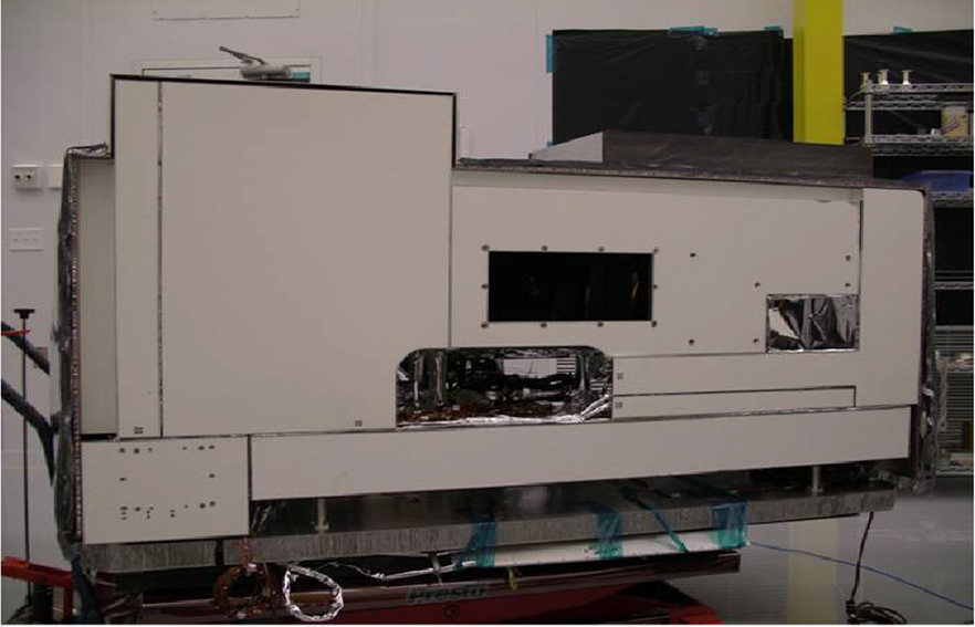
FIGURE 2. GIFTS instrument prototype built and tested by Ball Aerospace, for NASA, as part of the New Millennium program.
YOO Approximately how much will you charge for data and various information products?
HALL We want to be fully open and transparent about our business and our technology because it is so transformational. We are working with partners, resellers, data companies, and we are developing a wide range of products and pricing options. We know what the governments of the world have spent to collect current weather data. We will be able to significantly reduce costs while providing advanced data over what it costs the taxpayer today.
YOO Who will be your target customers?
HALL We have spent the last 12 months carefully examining the weather data industry and believe that all forecasters will benefit from our clear, accurate, persistent looks at the atmosphere with our advanced sounding technology. Certainly, national meteorological agencies from governments around the globe will look to this data to enhance their forecast accuracy. The media, and those who give us all our daily forecasting, will appreciate our capability to provide enhanced accuracy. But at the top of our pyramid are commercial interests, particularly insurance companies and anyone who deals with weather risk management in commercial sectors like aviation, energy, agriculture, transportation, shipping and a variety of other sectors which see constant complications from weather events and which, increasingly, have their own meteorologists on board to help mitigate weather-related losses.
YOO When will you actually begin to deliver data to customers?
HALL We will likely have our first sensor on orbit in 3 years. Then, after a period of time to calibrate and bring weather observation data online, we would have this powerful and transformational approach to forecasting in place, transmitting game-changing data. Our current plans have us delivering data by mid-year 2018. Currently we are on schedule to meet our commitments.
YOO Do you plan to have a Foundation? If so, what will be the primary purpose?
HALL Let me just say this. I have been a venture capitalist and a strategic investor for many, many years. My wife and I decided long ago that as we create wealth, it is never our money. Rather we are stewards of that wealth and the only thing we can do in this life is to bless the lives of others. For some 20 years we have operated a family fund that supports some 30 charities.
But let me add this: my interest in founding and operating Tempus Global Data was the result of three important things. First, the technology is disruptive and badly needed. We believe that forecasting will get better and better by quantum leaps forward. Second, it is an extraordinary business opportunity that will return tremendous value to our shareholders.
Third, this is about saving lives. It will be our intent to help all nations of the world achieve greater safety for their citizens with improved forecast accuracy. We are creating the Tempus Global Data Foundation with a portion of profits being used to help victims of violent storms ñ charities on the ground that help displaced families and groups that help re-build homes, communities and infrastructure.
More than anything else, our efforts are about saving lives. We canít stop weather, we canít prevent the damage it causes, but we can get people out of the way of severe weather events. There are many countries, like the Philippines, that have no advanced warning systems. We weep when we see 7,000 lives lost in Tocloban in 2013. We believe something must be done, and we are doing it.
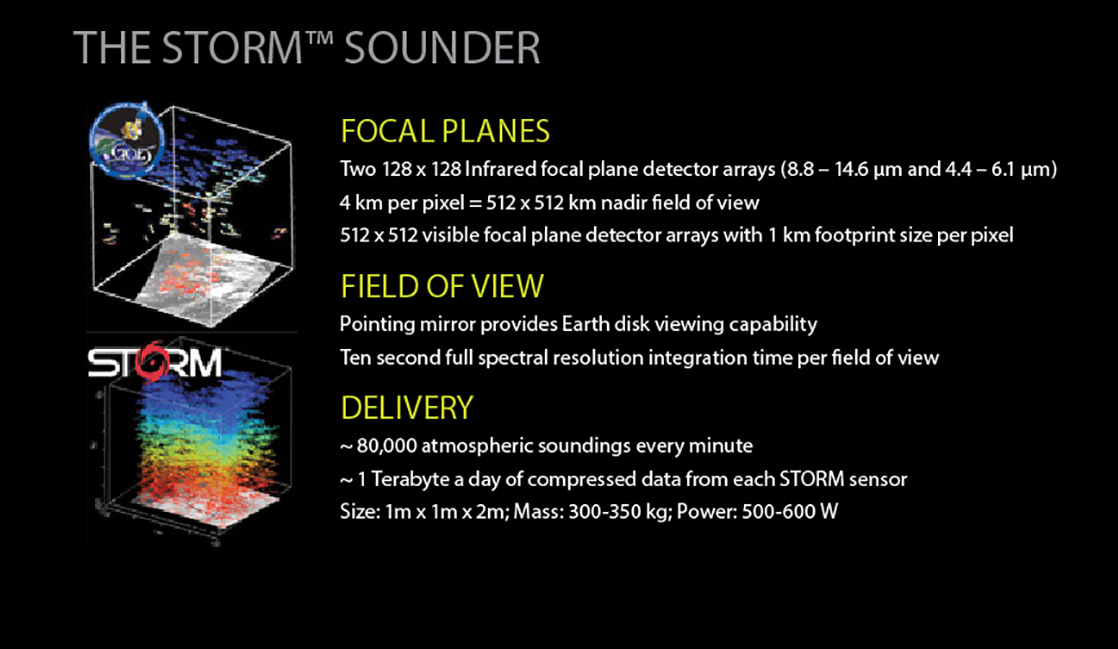
FIGURE 3.
Details of Tempus’ STORM instrument, with graphic of current derived wind vector sounding products from GOES.