Because of this association between the richness of a deposit and its geomorphology, high-resolution DEMs are a critical dataset in developing alluvial geomorphic models of the deposit zones
His name is Samuel.
It is just after 10:00 am and he has already walked for two hours from the small hut with a thatched roof and dirt floor in the mining camp where he stays. The sun beats down and the temperature steadily climbs. There is no shade to provide relief; the trees that once stood here have been cleared. Samuel is waist deep digging with two other men in a pit near a small stream. In the past few days, he and the other men have excavated enough earth to fill a large suburban backyard swimming pool. Their only tools are shovels and a small motorized pump to keep water from ponding in the bottom of the pit. Seven years ago, Samuel left his home in Sierra Leone after having witnessed the brutality of civil war. “I came here looking for work,” he says. “I came here to find a big diamond, so that one day I will be a rich man and be able to return home.”
Nearly 700 kilometers overhead, a satellite passes silently through space and records images of the area where Samuel and hundreds of others like him labor to find diamonds in this West African border region.
CONFLICT DIAMONDS
Many of Africa’s diamond deposits are mined not by industrial companies, but rather by artisanal miners like Samuel, who employ rudimentary tools such as picks, shovels, and sieves to unearth the diamonds (see Figure 1). Unlike large companies such as DeBeers and ALROSA, which utilize extensive geophysical and geologic prospecting methods to locate economical diamond deposits, artisanal miners operate largely through guesswork. As a result, they expend an abundance of time and effort, with no certainty of success, and leave tracts of damaged forests, soils, water systems, and wildlife in their wake.
The deposits worked by artisanal miners are typically alluvial in nature. Alluvial diamonds have eroded from volcanic kimberlite or lamproite source rock formations and have been deposited, sometimes hundreds of kilometers away, in river beds and floodplains. They are often located in remote areas, including near or inside of protected areas and other critical ecosystems, rendering them difficult to regulate and monitor.
Artisanal mining is a high-risk, high-reward occupation with unclear or informal legal rights that can render miners vulnerable to exploitation by governments or armed groups. Exploitation often occurs either because the miners are not registered with the government, they lack legally recognized rights to the land or to resources they are mining, or they sell their diamonds through informal or illegal trade networks.
The issue of “conflict resources” emerged during the late 1990s, as details of the diamond-financed rebel uprisings in Sierra Leone, Liberia, and Angola gained public and political attention. The term has since come to refer to any natural resources that are sold or traded to finance and/or sustain violent and armed conflicts.
Examples include gold and diamonds, cocoa, bush meat, and timber. Of these, diamonds are perhaps the most well-known, popularized by the 2006 movie “Blood Diamond.” Diamonds are a highly valuable commodity, relatively easy to access and smuggle, and difficult to trace. As such, diamonds have continued to finance conflicts, most recently in Côte d’Ivoire.
To address the concern of conflict diamonds, the Kimberley Process (KP) Certification Scheme was established in 2002 by representatives of the diamond industry, non-governmental organizations (NGOs), and governments of diamond exporting and importing countries, with the goal of ensuring that rough diamonds traded by participating countries were not used by rebel movements, or their allies, to finance armed conflicts aimed at undermining legitimate governments.
The Clean Diamond Trade Act (Public Law 108-19) officially sanctions U.S. participation in the KP, and authorizes the U.S. Department of State (DOS) to engage with other U.S. government agencies to provide technical expertise to participating countries within the KP. The DOS (including the Special Advisor for Conflict Diamonds), the U.S. Agency for International Development (USAID), and the U.S. Geological Survey (USGS) Special Geologic Studies Project currently work in close partnership to assist several West African nations in mapping, monitoring, and performing national-scale assessments of their artisanally mined diamond deposits.
Collaboration also takes place between the U.S. government and the national mining ministry and civil society organizations of the countries receiving technical support. Such multilateral partnerships provide technical training, the transparent exchange of information among governments, civil society, and the general public, and support and training for host countries in assessing and regulating their diamond resources.
While diamonds have clearly been linked with political unrest and instability, artisanal diamond mining also has the potential to provide positive socioeconomic impacts, serving as a means of supplementary income and supporting the local economies of mining communities. However, there is a significant lack of data concerning the location and richness of the deposits, limiting knowledge of where diamonds can be mined economically. The collection and dissemination of such information would improve both the success of the individual miner and the effectiveness of the development programs that target these populations, as well as verify the value of the nation’s artisanal mineral deposits. Addressing this lack of data is an important part of understanding diamonds as a conflict resource and also as a potential development tool.
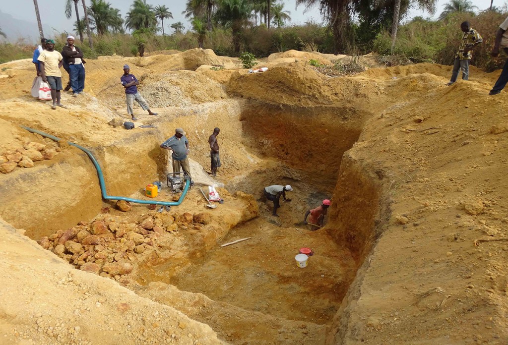
FIGURE 1.
A typical artisanal mining site: Workers begin mining in an area by digging a cluster of exploration holes until the presence of a thick and potentially rich gravel layer is found in the alluvial floodplain. Miners will then dig through several meters of sandy overburden mate- rial to access the diamondiferous gravel layer deep in the floodplain. When the gravel layer is reached, miners extract the ore and carefully sort and wash it in search of diamonds. This washing and sorting activity is completed within the active pit itself, in an adjacent pit that has filled with water, or in a nearby stream. It typically takes a team of three men one to three weeks to dig a pit, extract the gravel, and sort it for diamonds. Once the process is complete, the miners begin a new pit. Rarely, if ever, do the miners fill in previously mined pits. Old pits therefore remain exposed and typically fill with water. Photography courtesy of Peter Chirico, USGS.
THE ROLE OF SATELLITE IMAGERY
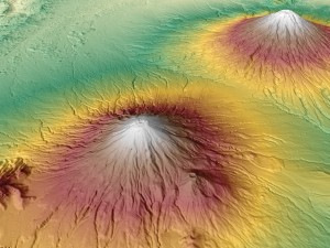
Satellite image interpretation of artisanal mine sites is an integral component of producing comprehensive assessments of alluvial diamond deposits. Repeat-pass, high-resolution commercial imagery, such as that from DigitalGlobe’s (Longmont, Colo.) WorldView-1 and WorldView-2 satellites, is used to perform change detection analysis in order to assess the location, size, and distribution of mining pits and activities (see Figure 2). Furthermore, stereo satellite image pairs, including those collected by DigitalGlobe’s IKONOS and GeoEye-1 satellites, are used to generate high-resolution digital elevation models (DEMs) to distinguish large mining pits and subtle landform features, such as paleochannels, alluvial flats, and terraces, which can indicate potential diamond deposition and accumulation (see Figure 3.) The identification of heavily-mined areas and new mining zones through these methods helps direct fieldwork aimed at assessing the deposits and the communities who mine them, and enables researchers to be more efficient in these challenging and often difficult-to-access regions.
During the satellite image interpretation process,individual mine pits are identified and assigned an estimated activity level and type of mining activity. Interpreters identify pits as being active or inactive, exploration or extraction pits, and measure their dimensions. Active pits typically exhibit a rim of brightly reflective excavated sediment material surrounding the edge of the pit and nearby spoil material piles (see Figure 4). In addition, the bottoms of such pits contain little or no water as miners frequently use pumps to drain pits during the excavation process. The presence of water is a key indicator of inactive mining, as is the presence of vegetation around the outer rim of the pit.
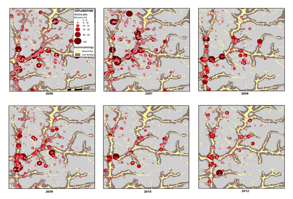
FIGURE 2.
A time-series analysis showing active artisanal mining extraction pits at a site in West Africa, created from a series of high-resolution satellite images documenting mining activities from 2006-2012 (2011 omitted because of differing image extent). Changes in the location and size of the pits are visible, and provide insight into the activity level within the study area from year to year. Graduated symbols correspond to the size of pits. Images courtesy of USGS.
Active mining pits may range in size from 1-30+ m in diameter, and are frequently several meters deep. Exploration pits are usually 1-3 m in diameter and are dug as test pits to determine if diamonds are present at a particular location. If diamonds are not found, the miner will typically begin a new exploration pit nearby. If diamonds are found, the exploration pit will be expanded in order to improve the chances of discovering more diamonds. Pits located in the alluvial flat, or floodplain, tend to be deeper and have higher diamond potential, whereas pits located on terraces just above the floodplains are shallower and more easily accessed, but tend to contain lower grade deposits. Because of this association between the richness of a deposit and its geomorphology, high-resolution DEMs are a critical dataset in developing alluvial geomorphic models of the deposit zones.
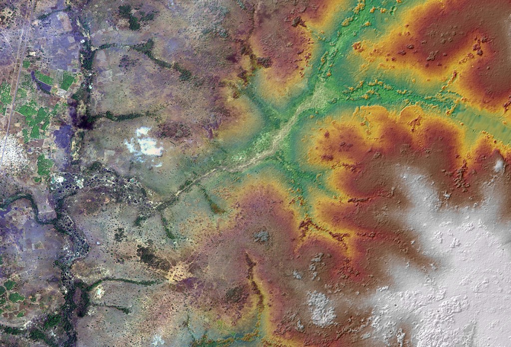
FIGURE 3.
A high-resolution satellite image merged with a high-resolution DEM near Fourouna, Côte d’Ivoire. The satellite image is a 2-m resolution WorldView-2 image collected on February 13, 2013. The elevation model is a 2-m DEM derived from DigitalGlobe’s IKONOS-2 stereo imagery collected on March 6, 2007.
![FIGURE 4. A comparison of oblique aerial photography on the right, and a Worldview-2 satellite image on the left. The Worldview-2 image, collected on Feb. 3, 2012, shows the intense mining activities of artisanal miners in a floodplain in West Africa. Oblique photography collected at the same site in June 2012 shows a detailed view of the active and inactive mining pits. [A] Large inactive mining pit which has now filled with water; [B] Two previously mined pits that have filled with water and sediment, indicating that they were recently used for washing and sorting gravel; [C] A recently abandoned pit with eroded headwalls that has not yet filled with water, indicating recent but completed activity; [D, E] Large active mining pits with the headwalls visible where miners are in the process of excavating. The particularly bright reflectance of the recently- removed spoil materials surrounding the pits in the satellite image is further evidence of the pits’ activity; [F] A cluster of small exploration pits in the low terrace geomorphic zone. Satellite image courtesy of Digital- Globe, Inc. Aerial photographs courtesy of Simon Gilbert, United Nations.](https://apogeospatial.com/wp-content/uploads/2014/02/Figure-4_Chirico1-832x1024.jpg)
FIGURE 4.
A comparison of oblique aerial photography on the right, and a Worldview-2 satellite image on the left. The Worldview-2 image, collected on Feb. 3, 2012, shows the intense mining activities of artisanal miners in a floodplain in West Africa. Oblique photography collected at the same site in June 2012 shows a detailed view of the active and inactive mining pits. [A] Large inactive mining pit which has now filled with water; [B] Two previously mined pits that have filled with water and sediment, indicating that they were recently used for washing and sorting gravel; [C] A recently abandoned pit with eroded headwalls that has not yet filled with water, indicating recent but completed activity; [D, E] Large active mining pits with the headwalls visible where miners are in the process of excavating. The particularly bright reflectance of the recently- removed spoil materials surrounding the pits in the satellite image is further evidence of the pits’ activity; [F] A cluster of small exploration pits in the low terrace geomorphic zone. Satellite image courtesy of Digital- Globe, Inc. Aerial photographs courtesy of Simon Gilbert, United Nations.
BEYOND CONFLICT DIAMONDS
The ability to obtain accurate and detailed information on artisanal mining activities by satellite is invaluable for researchers and policy makers, and greatly assists in the assessment of deposits that are difficult to access, as they are remote and have associated safety concerns. While this method has been implemented in support of the KP’s mission to end the trade of conflict diamonds, researchers are now employing similar techniques to assess and monitor other conflict minerals, such as the artisanal mining of tantalum, tungsten, tin, and gold in the eastern Democratic Republic of the Congo, a region destabilized by decades of conflict.
More accurate and detailed information on artisanal mining also assists development programs aimed at formalizing and legalizing the sector, assisting in micro-financing investment, and implementing sustainable development initiatives that target artisanal mining communities. For example, detailed satellite imagery of existing and potential mine sites help to inform the most appropriate type and location of development intervention, from clarifying land tenure in diamond-rich areas to promoting complementary livelihoods in areas that may be less diamondiferous. In the Central African Republic, basic geologic data collected through satellite image analysis has assisted USAID’s Property Rights and Artisanal Diamond Development (PRADD) project’s mission to secure the land and resource rights of artisanal miners and to introduce successful environmental rehabilitation programs, such as aquaculture and vegetable arming, in exhausted mine sites.
CONCLUSION
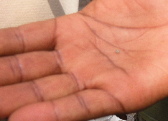
After a week of digging, Samuel has found one small diamond, not much larger than a grain of sand (see Figure 5). He will sell it to a diamond buyer in a nearby village for no more than $20, just enough money to buy food and supplies to sustain him for for a week or two. More important, it is just enough to keep his hope alive that one day he will discover a big diamond, become a rich man, and return home.

