By Jörg Herrmann, Sar Remote
Sensing Market Expert
Hutab Consulting
Uhldingen-Muehlhofen Lake Constance, Germany
The 10th anniversary of satellite-based commercial SAR (synthetic aperture radar) was just last year in 2017. This still-young discipline in the remote sensing world is bringing significant changes by introducing new capability levels with upcoming constellations, quarter-meter resolution, multi-polarization, and combined SAR/AIS collects. Because of all these SAR data volumes and diversifying features becoming accessible to the market in the coming years, there are new analytics capabilities, conventional or based on artificial intelligence coming up that will convert all these data into economically useful and actionable information.
In this article, I will outline some of the changes that are to be expected in the next five years. To put the evolution into a historic context, I will also take a look back to where the beginning of the SAR evolution, and how lessons learned led to trends.
COMING A LONG WAY
I somehow got engaged with SAR remote sensing when I started working in the space industry in 1980s, and very soon I felt a dedication to this matter — not so much because it is such an exciting technology, but rather because I had the impression that we have a measurement method at hand that could help solve a lot more problems than reconnaissance and scientific matters, the primary use cases of that time.
With Carl Wiley describing Synthetic Aperture Radar in 1959, and patenting the method in the U.S. in the 1960s, the foundation for the first space-based SAR was established: Seasat was launched in 1978, and demonstrated what was possible with SAR space, with 25-m resolution. In Europe and Canada, the space community hopped onto the train.
When I came into space, there were programs like ERS of ESA and CIR-C/X-SAR (U.S./Italy/ Germany) that gave researchers the opportunity to develop SAR applications, evaluate which SAR frequency works best for detecting which features, and to work on evolving the SAR sensor
technologies. The ERS 1+2 tandem mission paved the way for interferometric SAR applications, being further refined through airborne SAR campaigns.
Airborne SAR was also used for signature research, and to refine findings from SIR-C/X- SAR regarding picking the best frequency for an application. In the 1990s, airborne SAR operators started flying the first SAR mapping campaigns in the cloud-prone regions close to the equator where classical aerial photogrammetry failed or lead to long and costly campaigns.
While initiatives for commercializing satellite remote sensing with electro-optical cameras in the 1990s like IKONOS and Earlybird/Quickbird had their motivation in bringing photogrammetry into space and thereby becoming capable of delivering lower square kilometer prices than what was possible with aerial mapping, the same was happening with SAR. By the end of the 1990s, airborne SAR operators had demonstrated the topographic and thematic mapping capability that this method can deliver.
However, to bring SAR with such performance into space required a technological step, and the establishment of regulatory regimes to control such new capabilities in the context of avoiding political sensitivities. It also required, similar to the EO initiatives, establishing funding schemes, typically between public and private investors (public-private partnerships) to deploy the first commercial SAR satellites with a noticeable market impact in 2007: Radarsat-2 (MAXAR, formerly MDA), Cosmo Skymed (e-GEOS), and TerraSAR-X (Airbus Defence and Space). Each of these three systems came with specific strengths: image quality and location accuracy, temporal resolution based on a deployed constellation, large swath width, and optimization for maritime applications. Their operations required the establishment of new regulatory and licensing regimes.
The European/Canadian SAR community with its focus on maritime surveillance had early on selected C-band for their SAR missions. From ERS-1 and -2 this led to Radarsat-1, and later to Envisat with ASAR, and Radarsat-2.
The SIR-C/X-SAR community (U.S., Italy, Germany) had learned from their multi-frequency SAR experiment, flown on the Space Shuttle, that a high-SAR frequency provides textural information of the surface, while a low-SAR frequency contributes through its capability to penetrate the surface to thematic information. Combining a high- and a low-SAR frequency would therefore maximize the information content that SAR measurements from space can achieve. Consequently, the idea to install an X+L-band SAR in space became en vogue.
When I proposed the TerraSAR program in 1998, it was initially an X+L SAR. A U.S./German cooperation for a dual frequency SAR system followed the same objective, but had come to a hold before. Another dual frequency SAR proposal came then from Italy, combining the COSMO Skymed X-band SAR constellation with the Argentinian L-band SAR of the SAOCOM constellation. However, up to now, no X+L-band SAR is in orbit — but there are other ways to elicit thematic information from SAR.
SEEING THE FUTURE
With the current commercial SAR systems in orbit, it could be demonstrated that there are alternative ways (multi-temporal data collection, multi-polarization, and speckle diversity analysis) to get thematic maps out of SAR. Multi-temporal data merges are, however, dependent on revisit times. Constellations provide an advantage for this method. Very high-resolution SARs can also be used for pan-sharpening, thus fusing the SAR with multispectral optical data. See Figure 1.
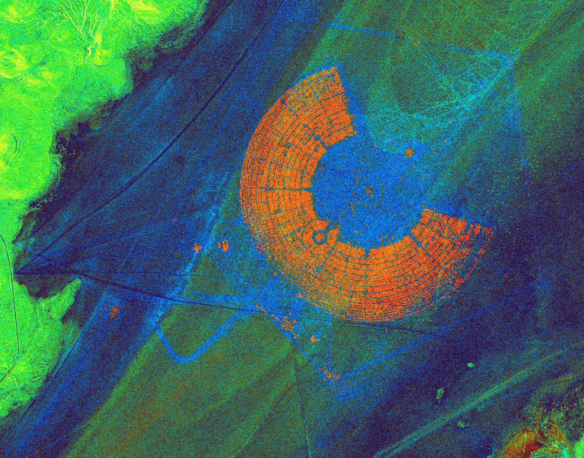
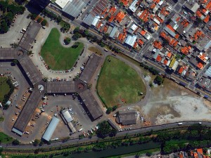
FIGURE 1
Multi-temporal SAR image of Black Rock City, home of the Burning Man Festival in the Nevada desert, using amplitude change detection to show the same place at three different times. The color stems from red, green, blue (RGB) annotations to three images. The orange shows the area at the time of the festival. If a pixel is unchanged during all three times of image collection, then the composition of RGB combines to a gray-scale of the radar images. If a color occurs, then this indicates a change at that time. Black Rock City is a nice example, because the participants of the festival arrive on a clean dessert floor and leave it again clean. Image courtesy of Airbus.
The bi-static SAR measurement approach that was demonstrated at global scale with the TanDEM-X mission, following up to the Shuttle Radar Topography Mission (SRTM), was a significant step in applying SAR to create a global, pole-to-pole, high-definition Digital Elevation Model (DEM). This step also formed a basis for worldwide coherent Digital Terrain Models (DTM), including Airbus’ WorldDEM product. The controlled formation flight of this mission was also a step, which may find refinement in the future, based on the lessons learned.
Over the years it became more and more obvious that a commercial SAR would require more than just the space infrastructure, but rather would need value chains put into place to deliver geo-information derived from SAR, and would need to overcome the disadvantage of SAR over EO: SAR imagery just looks strange to the human eye; only experts can interpret them.
Space engineers that drive SAR system development tend to forget about these value chains, which are essential to convert SAR measurements into valuable information that earn money in the market. This missing element of the downstream services has only very slowly evolved through numerous pilot and applications research projects.
However, the market hesitated to adopt because of limitations, asking for better resolution (geospatial, temporal, thematic) and better reliability and stability of information services that lead to customer solutions without requiring SAR experts to elaborate solutions on a project by project basis. So the SAR market stayed at a fraction of 10-15% of the overall remote sensing market for years.
STEPS INTO A GLORIOUS FUTURE FOR SAR
A SAR resolution is determined by flight direction (in flight direction it is largely driven by integration time over a spot on ground) through the spectral bandwidth that is available. For X-band SARs in space, the allowance for bandwidth was at 300 MHz, when the first commercial SARs were designed. The 300 MHz enabled 1-m resolution. After an extension to 600 MHz, the World Radio Frequency Conference in 2012 finally approved 1200 GHz of bandwidth in X-band for satellite SARs, corresponding to quarter-meter resolution.
Recently announced multi-static and dual-wavelength SAR systems have the potential to significantly improve the topographic/geodetic SAR measurement perimeter and the thematic mapping capabilities offered to the market. Digital elevation models measured from space could have
a posting of less than 5 m and vertical accuracies of better than 1 m. Companies with this plan include e-Geos, Airbus, Urthecast with OptiSAR, and XpressSAR.
Simultaneous collection of AIS signals and SAR imagery to detect uncollaborative vessels is becoming available (e.g. PAZ of Hisdesat, and coming soon Kompsat-6 of KARI/ SIIS, RCM of CSA, and Capella Space).
The trend of getting high-performance SAR satellites in very compact and light designs had been announced before as early as 2001, assuming that all the required technologies would over time come into place. This trend now seems to be materializing due to smart antenna deployments, advanced power and computing equipment. Such concepts will be the basis for constellations with up to more than 30 satellites, ensuring revisit time of a few hours and repeat cycles for interferometric analytics of less than a day. By entering this new category of timeliness, some of the long-pursued SAR use cases start becoming relevant in the market.
Finally, the significant increase in numbers of SAR data sources will lower the price for the SAR “raw material” to levels that help the
downstream services to become a lot more cost efficient and attractive in terms of pricing. While there is reliable C-band continuity in Canada and Europe, there is a clear trend for X-band in the commercial sphere. See chart in Figure 2.
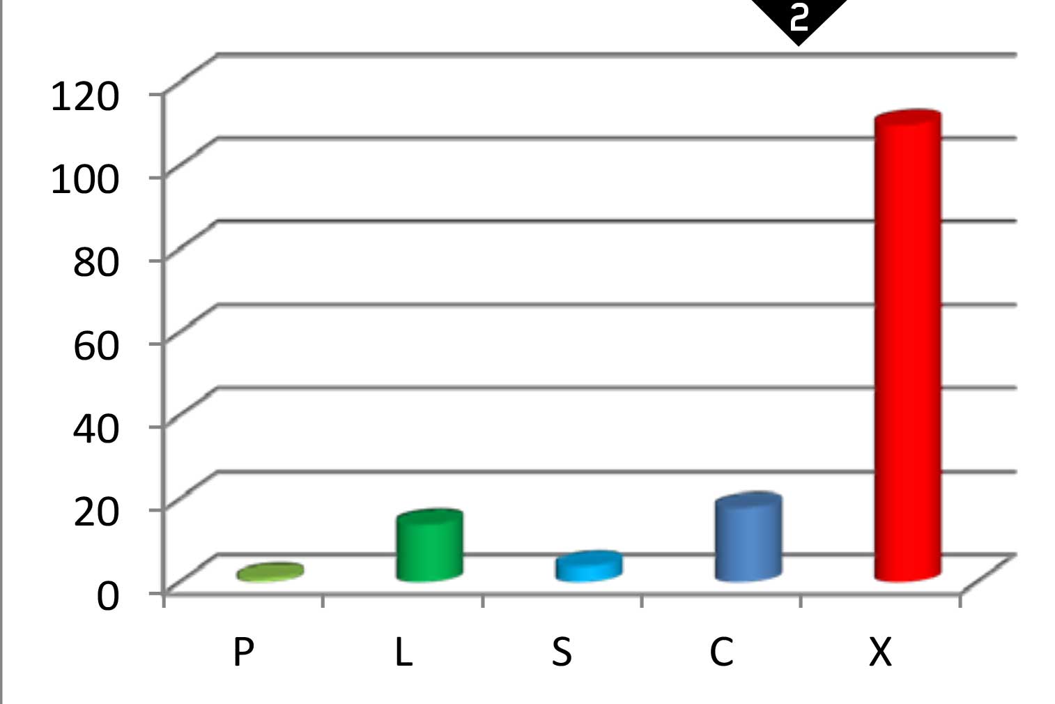
FIGURE 2
Number of SAR sensors announced to be in space (vertical axis) by 2023 by spectral band (horizontal axis).
Besides the high-end X-band SAR systems, there is this new category of larger constellations, also mainly going for X-band SARs. While high-end SARs strive for very high resolutions (target 25 cm), maximum image quality with high signal to noise ratios (NESZ < -19 dB), applying digital beam forming for VHR over a wide swath, multi-polarization, or with multiple phase centers in the SAR antenna supporting Ground Moving Target Indicator (GMTI), the constellation SAR sensors are characterized by compromises for compactness.
These SARs are being stowed into a tiny volume for launch and go through a metamorphosis after separation from the launcher to deploy to a well-sized SAR. These constellation SARs are therefore fitting onto a micro satellite (< 100 kg). This new compactness is the basis for fitting 4-8 satellites, or more, onto a launch vehicle and supporting the concept of larger constellations. Numbers of 12 to 50 satellites into a constellation are being announced. Launch service providers gain their experience for such fleet sizes to be launched from the telecommunication sector, where the constellations go up to 1000 satellites, and from the optical satellite constellations like the one of Planet. See Figure 3.
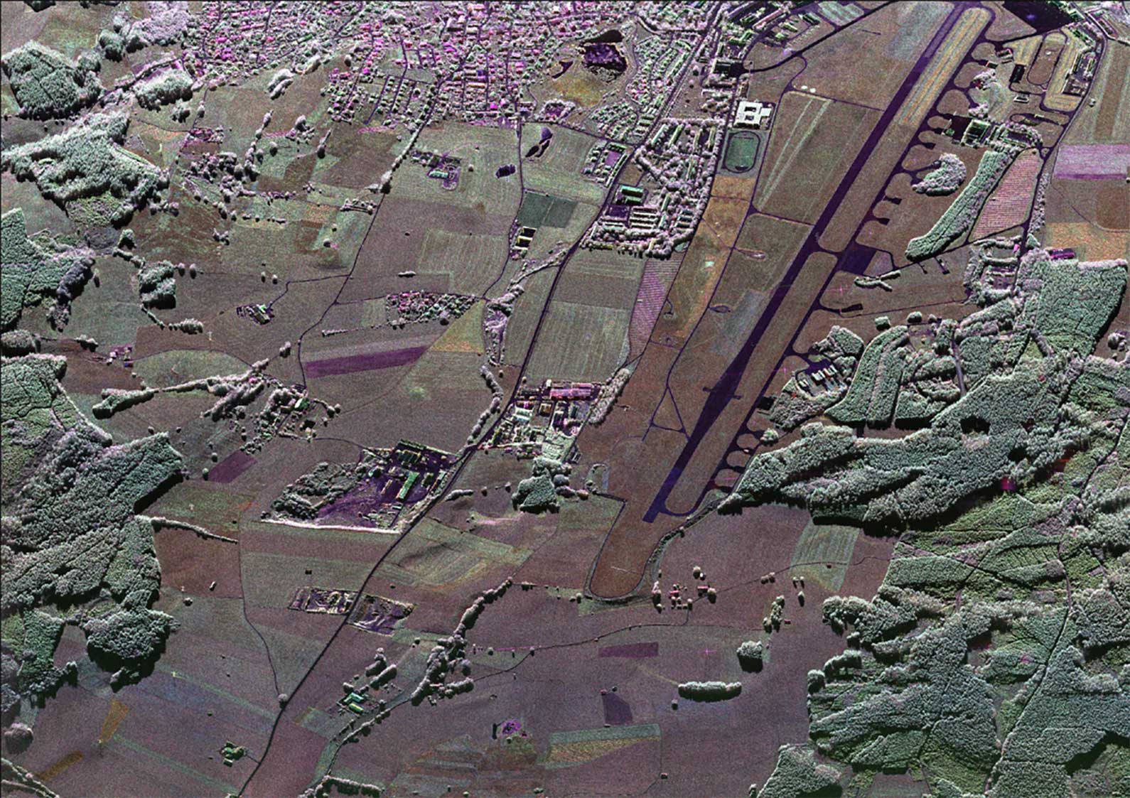
FIGURE 3
This SAR image near Kaufleuren in Bavaria, Germany, shows an air force base and many features, including fighter aircraft, the active airport tower, and power lines. The image shows 25-cm full-polarimetric SAR demonstrated by F-SAR, DLRís airborne system. Image courtesy of DLR, the German Aerospace Center.
There has been doubt among the SAR community if such compact designs can deliver any useful imagery and this with endurance over adequate orbit times and lifetime. Now the first of its kind has been launched in January this year by ICEYE, and it works: 10-m resolution SAR imagery from
a prototype, and a plan of reaching 3-m resolution with future satellites. Further players in this segment include Capella Space, MicroX SAR of JAXA, MicroSAR System of Space Norway with KSAT, and Umbra Labs. All of them are striving for high temporal resolution and faster INSAR cycling in support of reliable monitoring.
The venture capital community has spotted the trend for X-band SAR constellations establishing the grounds for real and reliable monitoring from space. From the fundraising announcements, it is expected that private equity and loan investments could exceed $100 M this year.
Object analytics and recognition under the broad range of SAR sensing parameters (viewing and aspect angles, operating mode, signal/noise, frequency, polarization) is a candidate to benefit significantly from artificial intelligence. Machine learning has been initiated to demonstrate how space-based SAR can in the future be translated on-the-fly into valuable and actionable information.
It has been demonstrated that geodetic control points can be measured from space radar (e.g. DLR’s DriveMark), for instance as contribution to the future navigation maps, in particular in support of autonomous driving. The method capitalizes on persistent scatterer analysis of very high-resolution SAR.
Value added service providers that apply interferometric SAR (INSAR) analysis can benefit from free Sentinel-1 SAR data to grow their
business. Consolidation and integration into vertical sector groups has likely improved the production efficiency and operational capabilities among these players.
CONCLUSION
The performance, number and diversity of satellite-based SAR sources will go through a significant improvement and growth in the next five years, while accessibility to data and information services will reach a quality and level of reliability that should put the commercial SAR community into a position that is close or equal to that of the commercial electro-optical satellite imaging community. Fingers crossed, friends of radar!